Mesa Chijuilla South Hike
In Cuba Region
Map File Source: DeLorme
 Hike Key: H10252
Last Updated: 12/15/2020 12:00am
Last Updated By: Marilyn Warrant
Hike Class: B (Moderate)
Hike Distance: 5.5 mi
Minimum Elevation: 6985 ft
Elevation Change: 250 ft
Total Uphill: 450 ft
Total Downhill: 450 ft
Avg. Grade: 3 %
Route Type: CCW Loop
On Trail: No
Paved or Gravel Roads: No
GPS Advised: Yes
Drive Distance Round Trip: 180 mi
Drive Time One-Way: 1:45
Hiking Seasons: Spring, Fall, and Winter
New Mexico Game Unit: 7
Hike Status: Published
Highlights
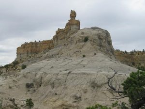
Sandstone and badlands formations.
CautionsNone.
Trailhead Directions
From Albuquerque take I-25 north to Bernalillo. At Bernalillo take US 550 west to the intersection with SR 197 in Cuba. Turn left and drive 9 miles to the DIRT road at the bend in SR 197. Turn right onto the dirt road which immediately turns left and heads west. Drive 0.2 miles to a NORTH bound road on the right. Turn right and go 3.2 miles to a road coming in from the right at the bottom of a short steep pitch. The PARK location is on the right side of the road between the wye of two side roads.
Actual Hike
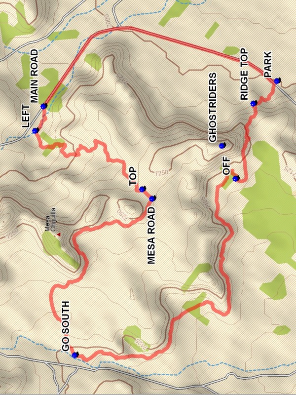
Start the hike by going up the road. At MAIN ROAD (1.2 mi) leave the road on the left and follow the small arroyo. After about 0.1 miles there is a small LEFT (1.3 mi) branch. Take this winding branch to the 0.2 mile point where a fence is encountered. Go under the fence on the right side. Go straight toward a blockage, going up on the right bank to get past the blockage. Continue in the arroyo and curl around to the right and up out of the small canyon. Once out there are large expanses of sandstone floor and badlands formations on the left. At the bottom of a small mesa ascend and there will be a two track which goes to the TOP (2.1 mi) of the mesa. Follow the road to an old well pad and turn right on a road which will turn to the northwest. Leave the MESA ROAD (2.2 mi) and go up over a ridge, then follow along the base of the actual Chijuilla Mesa until you rejoin the mesa road. Reach the GO SOUTH (3.3 mi) point and follow along the base of the mesa. Continue south along the base of the mesa, skipping the larger indentations until the GHOSTRIDERS base is reached. Go OFF (4.9 mi) of the ridge. After passing the formation stay on the ridge to the south of the emerging canyon. At the RIDGE TOP (5.3 mi) point descent to the south and go east to the road and parking.
Comments
The hike is on BLM administered land. When approaching Mesa Chijuilla from the south on the road, some people see a group of riders on horseback high on the mesa point. Others see a stone train. Depends on your favorite mode of riding.
WaypointsDIRT: N 35 57.382, W 107 05.520
GHOSTRIDERS: N 35 59.917, W 107 05.252
NORTH: N 35 57.392, W 107 05.734
PARK: N 35 59.714, W 107 04.957
MAIN ROAD: N 36 00.573, W 107 05.073
LEFT: N 36 00.604, W 107 05.183
TOP: N 36 00.211, W 107 05.450
MESA ROAD: N 36 00.173, W 107 05.492
GO SOUTH: N 36 00.458, W 107 06.203
OFF: N 35 59.866, W 107 05.402
RIDGE TOP: N 35 59.801, W 107 05.059
Hike GPS File Name: MesaChijuillaSouthWayTrack_DBDB.gpx
Hike GPS File: Click link to download hike waytrack file
Text Author: Dick Brown
Map Author: Marilyn Warrant
Waypoints Author: Dick Brown
Track Author: Dick Brown
Maintainer: Not Assigned
Editor: Howard Carr