Peralta – Paliza Loop Hike
In Jemez Mountains Region
Map File Source: DeLorme
 Hike Key: H10244
Last Updated: 11/23/2021 12:00am
Last Updated By: Marilyn Fixer
Hike Class: C (Challenging)
Hike Distance: 4.7 mi
Minimum Elevation: 9190 ft
Elevation Change: 530 ft
Total Uphill: 776 ft
Total Downhill: 776 ft
Avg. Grade: 10 %
Route Type: CCW Loop
On Trail:
Paved or Gravel Roads:
GPS Advised:
Drive Distance Round Trip: 160 mi
Drive Time One-Way: 2:00
Hiking Seasons: Spring, Summer, and Fall
New Mexico Game Unit: 6A
Hike Status: Inactive
Highlights
Hike to the head of Peralta Canyon.
CautionsNone.
Trailhead Directions
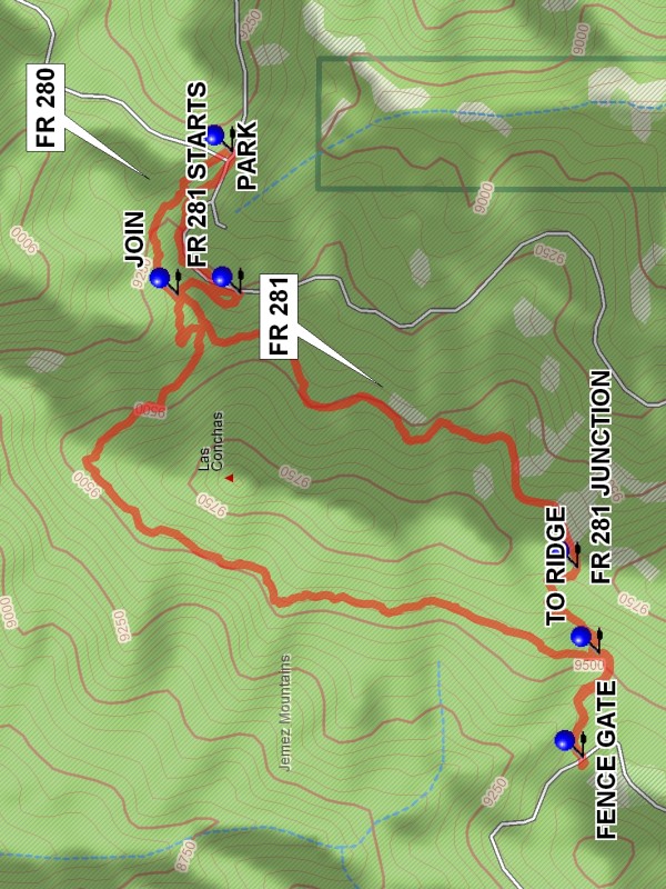
From Albuquerque take I-25 N to exit 242, Go west on US 550 to San Ysidro. Go right (north) on SR 4 to La Cueva. Continue on SR 4 for 12.4 mi. east to one quarter mile past milepost 38 in the Valle Grande area. Turn right onto FR 280. Drive for a little over two miles to a “K” intersection of roads and PARK (0.0 mi).
Actual Hike
The hike starts in the woods at the edge of the grassy knoll to the west of the road. After about 0.4 miles at JOIN (0.4 mi), the trail and FR 281 are only about 50 feet apart. The trail veers away to the northwest and climbs to the Los Conchas Peaks ridge. Turning southward, the trail runs along the west side of the ridge for most of the distance to the head of Paliza Canyon. The trail turns into a grassy one track and drops down, turning northward to the head of the canyon. Go through the FENCE GATE (2.4 mi) and pick a nice view spot for lunch. Or wander down the two track which descends down Paliza Canyon for a few hundred feet to the “Aviary”, where a symphony of birds may be found. To return go back through the fence gate (close it). After about 0.2 miles the route steepens. In about 0.1 more miles there will be a worn ATV trail going up steeply to the right. Yes, take this trail. The ascent will be 250 feet in 0.3 miles to the ridge and the FR 281 JUNCTION (2.9 mi). The rest of the hike is easy. Go left on the road and go for 1.3 miles to FR 281 STARTS (4.3 mi) and go left. This is FR 280, the road in. Then it is 0.4 more miles back to parking.
Comments
For a less strenuous hike to the head of Paliza Canyon see the Peralta – Paliza hike, an in-out hike. This hike can be done in a clockwise direction to avoid the steep up section to the ridge on the return in favor of a steep down section on the way in. Or try a figure eight using the JOIN (0.4 mi).
Set inactive until someone verifies that the hike is attractive and can be done.
WaypointsFR 280: N 35 49.660, W 106 29.835
PARK: N 35 48.114, W 106 30.762
JOIN: N 35 48.203, W 106 31.050
TO RIDGE: N 35 47.514, W 106 31.773
FENCE GATE: N 35 47.541, W 106 31.983
FR 281 JUNCTION: N 35 47.549, W 106 31.600
FR 281 STARTS: N 35 48.101, W 106 31.047
Hike GPS File Name: Peralta-PalizaLoopWayTrack_DBDB.gpx
Hike GPS File: Click link to download hike waytrack file
Text Author: Dick Brown
Map Author: Marilyn Warrant
Waypoints Author: Dick Brown
Track Author: Dick Brown
Maintainer: Not Assigned
Editor: Howard Carr