Corrales Lateral Loop Hike
In Corrales Region
Map File Source: DeLorme
 Hike Key: H10233
Last Updated: 03/04/2021 12:00am
Last Updated By: Marilyn Fixer
Hike Class: C (Challenging)
Hike Distance: 8 mi
Minimum Elevation: 5010 ft
Elevation Change: 22 ft
Total Uphill: 29 ft
Total Downhill: 29 ft
Avg. Grade: %
Route Type: CW Loop
On Trail: Yes
Paved or Gravel Roads: Yes
GPS Advised: No
Drive Distance Round Trip: 20 mi
Drive Time One-Way: 0:30
Hiking Seasons: Spring, Fall, and Winter
New Mexico Game Unit: 9
Hike Status: Published
Highlights
Walk along a drain in Corrales, return on a trail along the Rio Grande.
CautionsNone.
Trailhead Directions
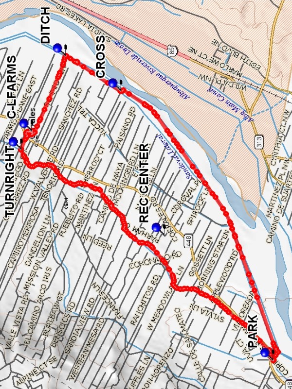
Go across the Alameda Bridge to the West Side and turn right on SR448, Corrales Road. Go north about 1/2 mile and PARK (0.0 mi) on the east side of the road (the parking area is opposite Cabezon Rd).
Actual Hike
Walk on the right-hand side of Corrales Rd a short distance, then cross the road and walk the ditch bank to TURN RIGHT (Olguin Rd). Walk along this road until you come to the Curtis-Losack Farms (5606 Corrales Rd) (C-LFARMS (3.5 mi)). If you call them beforehand, they might be willing to give a tour of their apple processing area. After lunch, go back the way you came, or head southeast on Paseo de Dulcelina Rd until you reach the Sandoval Lateral next to the Rio Grande. At CROSS (5.1 mi), cross over the canal and walk along the other side back to the parking area.
Comments
Another lunch option would be to go directly to the river (convenient bushes). In 1/10, we saw construction of another crossing where a canal comes into the river (Bernaval Rd). The Corrales REC CENTER at 500 Jones Rd has porta potties that we can use if necessary.
WaypointsREC CENTER: N35 13.273, W106 37.307
PARK: N35 12.421, W106 38.509
TURNRIGHT: N35 14.390, W106 36.486
C-LFARMS: N35 14.307, W106 36.312
DITCH: N35 14.043, W106 35.587
CROSS: N35 13.612, W106 35.924
Hike GPS File Name: CorralesLateralLoopWayTrack_MWMW.gpx
Hike GPS File: Click link to download hike waytrack file
Text Author: Marilyn Warrant
Map Author: Marilyn Warrant
Waypoints Author: Marilyn Warrant
Track Author: Marilyn Warrant
Maintainer: Not Assigned
Editor: Howard Carr