Ojito Hoodoo Loop Hike
In Ojito Region
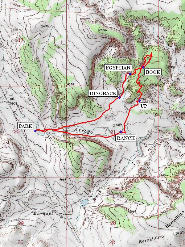
Map File Source: NG Topo
 Hike Key: H10214
Last Updated: 03/04/2021 12:00am
Last Updated By: Marilyn Fixer
Hike Class: A (Easy)
Hike Distance: 4.1 mi
Minimum Elevation: 5892 ft
Elevation Change: 144 ft
Total Uphill: 194 ft
Total Downhill: 194 ft
Avg. Grade: 4 %
Route Type: Loop
On Trail: No
Paved or Gravel Roads: No
GPS Advised: Yes
Drive Distance Round Trip: 100 mi
Drive Time One-Way: 1:15
Hiking Seasons: Spring, Fall, and Winter
New Mexico Game Unit: 9
Hike Status: Published
Access Description: Ojito Wilderness Area Access
Highlights
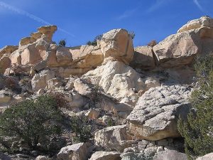
Exceptional collection of sandstone and badlands formations.
CautionsNone.
Trailhead Directions
From Albuquerque take I-25 north to exit 242, US 550 west from Bernalillo past Zia Pueblo. At milepost 21 turn off to left on Cabezon Rd. Take left fork (right goes to gypsum mine). Drive about 12 miles to the PNM pumping station. Turn right (northwest) and drive another 2.4 miles. Go past a corral and you’ll come to a pond far off on the right that will usually be dry. Look for a grove of tamarisk (salt cedar) bushes and an embankment. Turn off to the right and head for that embankment and park.
Actual Hike
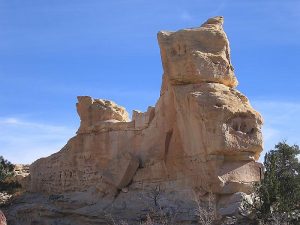
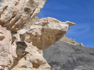
Hike up onto earthen dam and follow it south and around to the east to its end and keep going in that direction. Follow the top of the dam. Cowpath leads to fence at base of cliffs. Continue on past “Tomahawk Rock.” Leave path and go straight. Go to the ruins of an old RANCH (1.0 mi) house and barn out in the valley. Head north toward the other side of the valley heading slightly east of the lone butte. Along the top of the bluff see sort of a window (gap in the rocks with sky in it). Head for that, crossing a fence, as you approach the bluffs. That is where the best access up to the top of the mesa is. Climb UP (1.5 mi) onto the mesa and at its north end descend using a narrow passage on the west. Head for the black base of the butte. Here you can find glass-like minerals (selenite) in the black rock crumbs. Also here is Winged Rock (that also resembles a BOOK (2.0 mi)). Go northeast around the butte and explore “The Waiter” a rock with a “hand holding a tray” over it and a “window rock” nearby. Go back and west past Winged Rock and walk atop the honeycomb floor, view a dry waterfall, descend from a ledge and have lunch near “The Teapot” (that from another angle looks like an EGYPTIAN (2.7 mi) statue) and other fantastic rock formations. Return to parking area by bushwhacking west and southwest back down the valley, passing “The Bakery” a group of rocks resembling rolls and loaves of bread (or a DINOBACK (3.0 mi)). Head back toward the gate in the fence along the far cliffs to the south. You can see the power lines, in the distance, that are your objective.
Comments
The original author of this hike, Roger Holloway, saw different shapes in the formations than later hikers. What do they look like to you?
WaypointsPARK: N 35 30.937, W 106 57.730
RANCH: N 35 30.933, W 106 56.736
UP: N 35 31.224, W 106 56.521
BOOK: N 35 31.542, W 106 56.477
EGYPTIAN: N 35 31.481, W 106 56.631
DINOBACK: N 35 31.256, W 106 56.752
Hike GPS File Name: OjitoHoodooLoopWayTrack_JBMW.gpx
Hike GPS File: Click link to download hike waytrack file
Text Author: Roger Holloway
Map Author: John Boyd
Waypoints Author: Marilyn Warrant
Track Author: John Boyd
Maintainer: Not Assigned
Editor: Howard Carr