Pino Trail to Crest Trail Hike
In Sandia Mountain West Region
Map File Source: DeLorme
 Hike Key: H10178
Last Updated: 03/20/2023 2:37pm
Last Updated By: Marilyn Fixer
Hike Class: E (Most difficult)
Hike Distance: 9 mi
Minimum Elevation: 6469 ft
Elevation Change: 2763 ft
Total Uphill: 2763 ft
Total Downhill: 2763 ft
Avg. Grade: 14 %
Route Type: InOut
On Trail: Yes
Paved or Gravel Roads: Yes
GPS Advised: No
Hiker Limit (NF/BLM/NP): 15 (Sandia Wilderness)
Drive Distance Round Trip: 12 mi
Drive Time One-Way: 0:15
Hiking Seasons: Spring and Fall
New Mexico Game Unit: 8
Hike Status: Published
Highlights
A strenuous hike on one of two major trails leading to the Crest from the westside of the Sandia Mts. Lots of tree cover at higher elevations and vistas of ABQ below.
CautionsSteep grades along trail; bring hiking poles and plenty of water.
Trailhead Directions
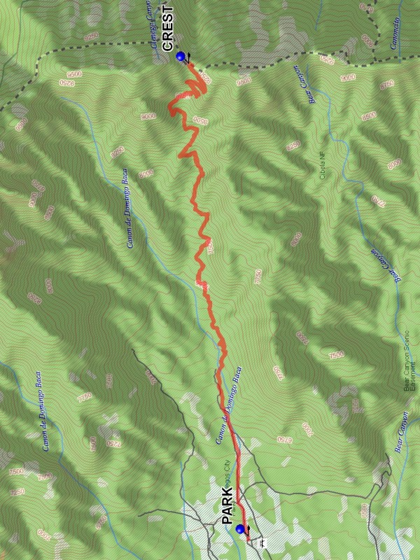
North on Tramway past Academy, look for signs leading right to Elena Gallegos Picnic Grounds and PARK (0.0 mi).
Actual Hike
Pino Canyon Trail 140 starts at the Elena Gallegos Picnic Grounds. It goes almost directly east up the mountain. The first part is easy and then gets steep. The last part that joins the Crest Trail (CREST (4.5 mi)) has very steep switchbacks.
Comments
Since the hike is on a north facing slope and is under tall pines, it is one of the coolest hikes on the west side of the Sandias so can be done even in late September.
WaypointsPARK: N 35 09.799, W 106 28.190
CREST: N 35 10.142, W 106 24.866
Hike GPS File Name: PinoTrailtoCrestTrailWayTrack_JBJB.gpx
Hike GPS File: Click link to download hike waytrack file
Text Author: Roger Holloway
Map Author: Marilyn Warrant
Waypoints Author: John Boyd
Track Author: John Boyd
Maintainer: Vivian Heyward
Editor: Marilyn Warrant