Faulty Loop Hike
In Sandia Mountain South Region
Map File Source: NG Topo
 Hike Key: H10163
Last Updated: 03/20/2023 2:28pm
Last Updated By: Marilyn Fixer
Hike Class: C (Challenging)
Hike Distance: 5.2 mi
Minimum Elevation: 6575 ft
Elevation Change: 1064 ft
Total Uphill: 1090 ft
Total Downhill: 1090 ft
Avg. Grade: 9 %
Route Type: Loop
On Trail: Yes
Paved or Gravel Roads: Yes
GPS Advised: Yes
Hiker Limit (NF/BLM/NP): 15 (Sandia Wilderness)
Drive Distance Round Trip: 40 mi
Drive Time One-Way: 0:30
Hiking Seasons: Spring and Fall
New Mexico Game Unit: 8
Hike Status: Published
Highlights
Travertine Falls, a beautiful place with a mighty dome of travertine with caves; the falls are at least fifty feet high, with rocks covered in green moss.
CautionsHiking poles recommended.
Trailhead Directions
To avoid confusion, take 333/Rt66 to Tijeras, NM (rather than I-40). From INT 333/337 (the intersection of NM 337 (Old South 14) and NM 333 (Old Route 66)), drive north under the overpass of I-40, as if you were going to access I-40 West. Instead of taking the I-40 Ramp on the left, turn right onto Arrowhead Trail Road (ARROWHEAD). Follow it to the end. Canyon Estates Trailhead is off the looped paved area.
Actual Hike
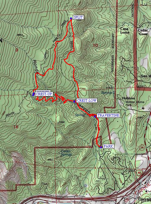
Follow Crest Trail 130 to where it doubles back to the right. The TRAVERTINE (0.4 mi) Falls are straight ahead. You will be coming back from there. Continue on Tr. 130, pass over Travertine Falls on your left, and cross the stream that feeds it. The trail to the falls goes off to the left, but continue on Tr. 130 past a couple of switchbacks, and take the Lower Faulty Trail (Tr. 195) sharply to the right at CREST-LOW (0.8 mi). Take Tr. 195 until you reach a double-back to the left called “Upper Faulty Trail” (Tr. 195A) at SPLIT (2.0 mi). Take Upper Faulty until you reach an iron ring full of rocks at JCT-CCC (3.3 mi), which marks the junction of Crest Tr. 130 at CREST-UP (3.3 mi) (just ahead) and CCC Tr. off to the right. You might want to have lunch here. It is sixteen to seventeen switchbacks from there down to the junction for Faulty Tr. 195. Continue on Tr. 130, crossing the stream and taking the unmarked trail off to the right down to the bottom of Travertine Falls. Then cross the stream again and go back to the Crest Trail and back to the parking area.
Comments
The hike up is much shorter than the one down. Don’t miss Travertine Falls. It is only a few minutes from the parking area but see it on the way back. It is a beautiful place. There is a mighty dome of travertine with caves in it and the falls is at least fifty feet high, covered in green moss. Faulty Trail goes all the way to Doc Long Campground but of course we hike only a short portion of it.
WaypointsAccess
INT 333/337: N35 04.771, W106 23.286
ARROWHEAD: N35 04.905 W106 23.245
Hike
PARK: N35 05.373, W106 23.494
TRAVERTINE: N35 05.696, W106 23.573
CREST-LOW: N35 05.849, W106 23.832
SPLIT: N35 06.717, W106 23.876
CREST-UP: N35 05.916, W106 24.360
JCT-CCC: N35 05.935, W106 24.350
Hike GPS File Name: FaultyLoopWayTrack_JBMC.gpx
Hike GPS File: Click link to download hike waytrack file
Text Author: Roger Holloway
Map Author: Marilyn Warrant
Waypoints Author: Mike Coltrin
Track Author: John Boyd
Maintainer: Howard Carr
Editor: Marilyn Warrant