Chupadera Peak Hike
In Socorro Region
Map File Source: DeLorme
 Hike Key: H10155
Last Updated: 12/15/2020 12:00am
Last Updated By: Marilyn Warrant
Hike Class: D (Difficult)
Hike Distance: 9.3 mi
Minimum Elevation: 4525 ft
Elevation Change: 1715 ft
Total Uphill: 1725 ft
Total Downhill: 1725 ft
Avg. Grade: 8 %
Route Type: InOut
On Trail: Yes
Paved or Gravel Roads: Yes
GPS Advised: No
Drive Distance Round Trip: 200 mi
Drive Time One-Way: 1:30
Hiking Seasons: Spring, Fall, and Winter
New Mexico Game Unit: 20
Hike Status: Published
Highlights
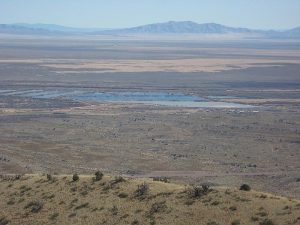
Strenuous hike to a high point with views of Bosque del Apache from above, rock formations.
CautionsDesert hike with no shade. Can be windy. Hiking poles recommended for steep top portion. Dress carefully, because you can also get hot going uphill.
Trailhead Directions
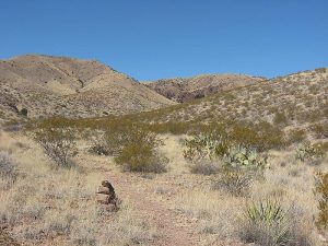
I-25 South past Socorro to exit 139 (San Antonio). Turn left on Hwy 380 then right on SR-1 just after the Owl Cafe. Travel 6.8 mi south from this intersection. Just past the 45 mile marker, there will be a small brown sign on the right. Turn right and go under the wooden RR trestle, about 1/2 mile to the parking area for the Chupadera Wilderness Trail.
Actual Hike
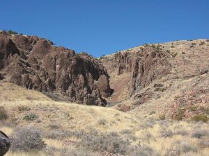
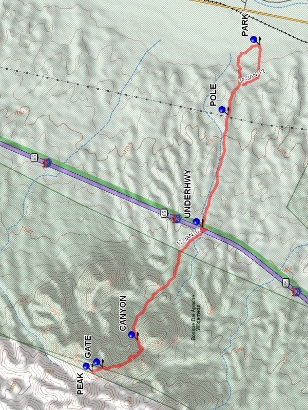
Hike from the Chupadera Peak trailhead, which is in the north section of the Bosque del Apache. At the beginning of the hike, there may be several options where trails cross, but keep a general westward direction to go by a power POLE (1.0 mi) and through a tunnel under I-25 (UNDERHWY (2.2 mi)). Now the pretty (and steep) part of the hike begins, as you hike to the Chocolate CANYON (3.8 mi), through a GATE (4.5 mi), and then to Chupadera PEAK (4.65 mi). The second half of the hike has an 11% average grade.
The hike can be done as far as the Chocolate CANYON to reduce the difficulty to a “C” hike (1100 feet climbing). Hikers who don’t want to do the full hike can always stop and wait for the others to return.
Comments
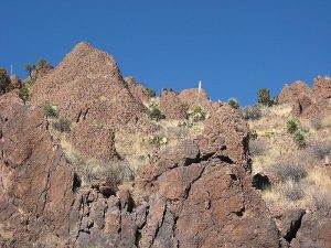
The trail has two distinct features. It crosses two habitat zones from the lower Sonora, characterized first by creosote bush, aka greasewood, to the upper Sonora with grass and several vegatation types such as soto and barrel cactus not native to the Albuquerque area. Also the red andesite-rhyolite ash flows tuffs form significant clifts at the Chocolate Canyon (named by one of our hikers), being some 30 million years old from the start of the rifting along the Rio Grande graben. Quail have been seen as well as damage to prickly pear cactus caused by the javelinas who live in the Chupadera Wilderness area.
WaypointsPARK: N33 49.344, W106 53.487
POLE: N33 49.625, W106 54.240
UNDERHWY: N33 49.853, W106 55.439
CANYON: N33 50.428, W106 56.653
GATE: N33 50.741, W106 56.943
PEAK: N33 50.831, W106 56.989
Hike GPS File Name: ChupaderaPeakWayTrack_MW.gpx
Hike GPS File: Click link to download hike waytrack file
Text Author: Theodore (Ted) Cooley
Map Author: Marilyn Warrant
Waypoints Author: Marilyn Warrant
Track Author: Marilyn Warrant
Maintainer: John Cooper
Editor: Howard Carr