10K North to Barite Mine Hike
In Sandia Mountain East Region
Map File Source: Garmin BaseCamp
 Hike Key: H10139
Last Updated: 03/20/2023 2:08pm
Last Updated By: Marilyn Fixer
Hike Class: C (Challenging)
Hike Distance: 6.7 mi
Minimum Elevation: 8750 ft
Elevation Change: 1030 ft
Total Uphill: 1765 ft
Total Downhill: 1765 ft
Avg. Grade: 9 %
Route Type: InOut
On Trail: Yes
Paved or Gravel Roads: Yes
GPS Advised: Yes
Hiker Limit (NF/BLM/NP): 15 (Sandia Wilderness)
Drive Distance Round Trip: 60 mi
Drive Time One-Way: 1:00
Hiking Seasons: Spring, Summer, and Fall
New Mexico Game Unit: 8
Hike Status: Published
Attractions: Forest and Rock Formations
Highlights
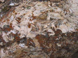
The barite mine site contains many interesting rocks not generally found in the Sandias. A fun place to look around after lunch.
CautionsLots of steady but gradual uphill on the return from lunch.
Trailhead Directions
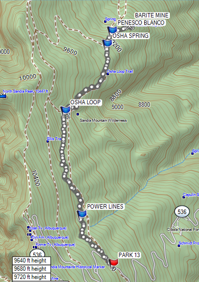
From Albuquerque take 1-40 east to Tijeras exit 175, then go north on SR 14 to SR 536. Go east up the mountain for 10.1 miles to PARK 13 (0.0 mi) on the right at the 10K parking lot. A three dollar fee or Golden Age Pass is required to park here.
Actual Hike
Note: This hike was formerly called the 10K North to Calcite Mine. The trail starts at the far end of the 10K parking area. The trail goes northward from that point, and is generally shaded by trees. The trail generally follows the contour line, going up and down but losing elevation. The trail goes under POWERLINES (0.7 mi), switches to a section of the OSHA LOOP (1.9 mi) trail, then continues on the OSHA SPRING (2.9 mi) trail to the intersection of the PENASCO BLANCO (3.0), stay straight on the Osha Spring trail to an interesting, abandoned BARITE MINE (3.2 mi). Barite is barium sulfate, a white, crystalline mineral. This mine is the Landsend (Lone Star) barite claim and was excavated by bulldozers which opened many wide pits 8-12 feet deep. In 1968 the Forest Service asked that the claim be declared and void. It was subsequently so declared in 1977. Have lunch at the mine and return the way you came.
Comments
Trail is so named because it generally follows the 10,000 foot contour line.
WaypointsPARK: N35 12.587, W106 26.123
POWERLINES: N35 13.021, W106 26.472
OSHA LOOP: N35 13.952, W106 26.654
OSHA SPRING: N35 14.548, W106 26.188
PENASCO BLANCO: N35 14.666 W106 26.131
BARITE MINE: N35 14.730, W106 25.472
Hike GPS File Name: 10KNorthToBariteMineWaytrack_HCHC.gpx
Hike GPS File: Click link to download hike waytrack file
Text Author: Howard Carr
Map Author: Howard Carr
Waypoints Author: Howard Carr
Track Author: Howard Carr
Maintainer: Howard Carr
Editor: Marilyn Warrant