Continental Divide South Hike
In Cabezon Region
Map File Source: DeLorme
 Hike Key: H10110
Last Updated: 02/07/2022 12:00am
Last Updated By: Marilyn Fixer
Hike Class: C (Challenging)
Hike Distance: 5.7 mi
Minimum Elevation: 6548 ft
Elevation Change: 196 ft
Total Uphill: 998 ft
Total Downhill: 998 ft
Avg. Grade: 8 %
Route Type: InOut
On Trail: Yes
Paved or Gravel Roads: Yes
GPS Advised: No
Drive Distance Round Trip: 140 mi
Drive Time One-Way: 1:30
Hiking Seasons: Spring, Fall, and Winter
New Mexico Game Unit: 7
Hike Status: Waiting Editor
Access Description: Cabezon Area Access
Highlights
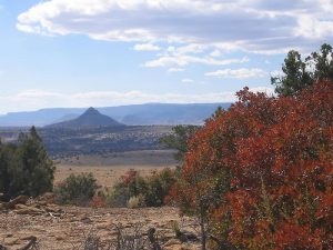
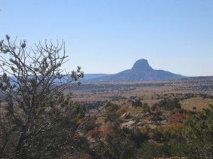
Hike along the edge of a mesa with sandstone formations. Views of Cabezon to the south and the many volcanic formations receding in the distance down the Rio Puerco valley. It’s enchanting and hard to beat.
CautionsSteep dropoffs. Not much shade.
Trailhead Directions
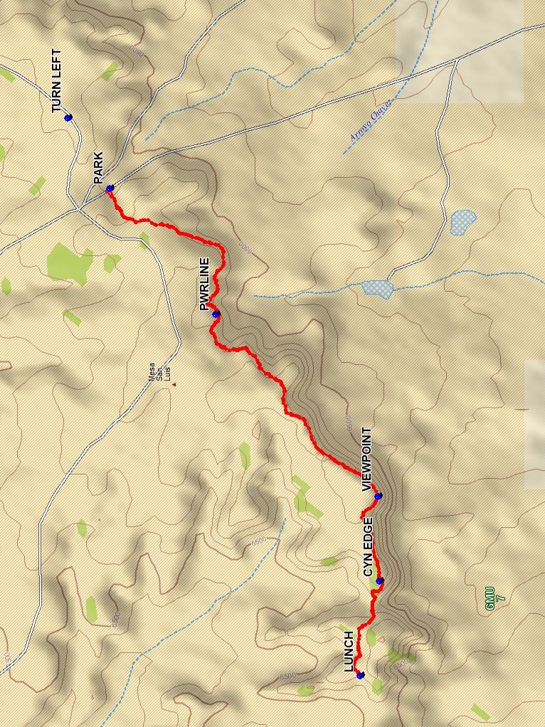
From Albuquerque take I-25 north to Bernallio and take 550 to San Ysidro. Drive 18 mi. west (and NW) to San Luis Rd (Hwy 279); turn left onto Hwy 279 and continue 8.5 mi. west (and SW) to TORREON RD (paved) where you will turn right (north) for 3.6 mi. At that point, TURN LEFT and drive to PARK (0.0 mi).
Actual Hike
Locate the CDT cairns on the right shoulder of PARK (0.0 mi) and start hiking westward. Follow the cairns along the mesa south rim providing spectacular views of the Rio Puerco valley, Cabazon Peak and many other volcanic plugs. Red sandstone bluffs, twisted juniper trees and soaring hawks all add to the splendor of your hiking experience. Pass the PWRLINE (0.9 mi) and continue.
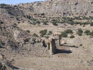
At VIEWPOINT (2.0 mi) enjoy the panoramic view. Take a brief stop at CYN EDGE (2.4 mi) just before heading down and up a ravine to LUNCH (2.9 mi). Enjoy a view into the valley to the west where there are a number of hoodoo towers. Afterwards retrace the trail along the mesa edge back to the vehicle, viewing the scenery from a different angle.
Comments
Hike data were determined using a Garmin GPSMap 62 and Garmin BaseCamp for TOPO US 24K Southwest.
WaypointsAccess
TORREON RD: N35 40.177, W 107 03.665
TURN LEFT: N35 42.486, W 107 06.312
Hike
PARK: N35 42.345, W107 06.607
PWRLINE: N35 41.985, W107 07.133
VIEWPOINT: N35 41.433, W107 07.895
CYN EDGE: N35 41.428, W107 08.249
LUNCH: N35 41.493, W107 08.644
Hike GPS File Name: ContinentalDivideSouthWayTrack_BG(4).gpx
Hike GPS File: Click link to download hike waytrack file
Text Author: Bill Gloyd
Map Author: Bill Gloyd
Waypoints Author: Bill Gloyd
Track Author: Marilyn Warrant
Maintainer: Bill Gloyd
Editor: Marilyn Warrant