Hidden Mountain Hike
In Los Lunas Region
Map File Source: NG Topo
 Hike Key: H10085
Last Updated: 03/07/2021 12:00am
Last Updated By: Marilyn Fixer
Hike Class: C (Challenging)
Hike Distance: 4 mi
Minimum Elevation: 5040 ft
Elevation Change: 385 ft
Total Uphill: 546 ft
Total Downhill: 546 ft
Avg. Grade: 5 %
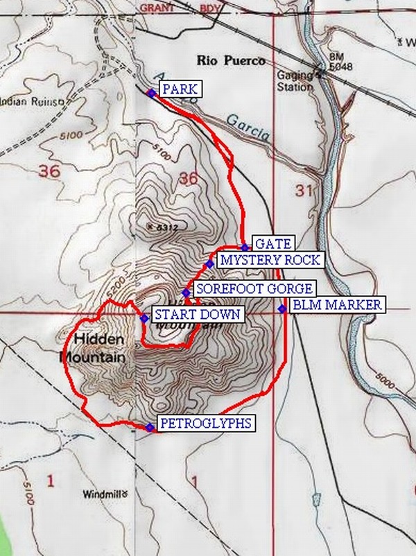
Route Type: CCW Loop
On Trail: No
Paved or Gravel Roads: Yes
GPS Advised: Yes
Drive Distance Round Trip: 80 mi
Drive Time One-Way: 0:30
Hiking Seasons: Fall and Winter
New Mexico Game Unit: 13
Hike Status: Published
Highlights
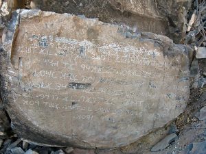
Mystery Rock, a vertical slab with “Phoenician” letters, lots of petroglyphs, great views to the north.
CautionsVery steep route both up and down the mountain with difficult footing over loose rock. Parts are 26% grade up, 16% grade down. Hiking poles recommended.
Trailhead Directions
I-25 south to Los Lunas (exit 203). West on SR 6 (starts at milepost 33) about 14 miles to between mileposts 18 and 19 (just past Rio Puerco bridge). Look for sign for landfill operation and railroad crossing. Turn left, drive across tracks to gate of landfill and PARK (0.0 mi).
Actual Hike
Walk through the maze on the east side of the road and hike east along dirt road toward end of the mountain. Watch for and follow a side road that goes off to the right toward the mountain that leads up to a fence. Look for a GATE (0.6 mi)in wire fence to the east of where the road meets the arroyo under the fence. Go through the gate and hike to the right for a while, parallel to the fence, then up a rocky trail into the canyon to MYSTERY ROCK (0.8 mi) (an inscription in “Phoenician” letters) in a vertical slab just on the left side of trail (easy to miss). Then follow the primitive trail on left of canyon bottom up through SOREFOOT GORGE (0.9 mi) . Parts of this are very steep, as much as 26% grade. There is an inscription “Sorefoot Gorge” above and right of your head. Scramble on up to the top left of the canyon where there are ruins of dwellings along a narrow ridge and great overlook to the north. You will probably see many trains coming and going throughout the hike. Have lunch up here. Then go south and west to highest peak, then START DOWN (1.5 mi) carefully to the base of the mountain on the other side. Some places have a 16% grade down over loose rock. Go around south and east side of mountain. There are a lot of PETROGLYPHS (2.3 mi) here. Follow the fence north and then west, past a BLM MARKER (3.0 mi) back to the gate and return to vehicle.
Comments
This hike is on New Mexico state trust land. The hike leader must obtain a one-day permit for an educational group (up to 25 people) for $5 by check. You’ll need to allow a few weeks for the state to process the request and return your permit. You can read about the mystery rock. A weed called Devil’s Claw (or Una del Gato Cat’s Claw) can often be found on the flats to the southeast of the mountain. No trees on this mountain so it can get very hot in the summertime.
WaypointsPARK: N34 47.586, W106 59.981
GATE: N34 47.162, W106 59.670
MYSTERY ROCK: N34 47.118, W106 59.786
SOREFOOT GORGE: N34 47.037, W106 59.867
START DOWN: N34 46.967, W107 00.003
PETROGLYPHS: N34 46.668, W106 59.987
BLM MARKER: N34 46.992, W106 59.546
Hike GPS File Name: HiddenMountainWayTrack_JBMW.gpx
Hike GPS File: Click link to download hike waytrack file
Text Author: Roger Holloway
Map Author: Marilyn Warrant
Waypoints Author: Marilyn Warrant
Track Author: John Boyd
Maintainer: Not Assigned
Editor: Howard Carr