4th of July – Albuquerque Trail Loop Short Hike
In Manzano Mountains East Region
Map File Source: NG Topo
 Hike Key: H10039
Last Updated: 06/29/2021 12:00am
Last Updated By: Marilyn Fixer
Hike Class: C (Challenging)
Hike Distance: 5.5 mi
Minimum Elevation: 7438 ft
Elevation Change: 810 ft
Total Uphill: 985 ft
Total Downhill: 985 ft
Avg. Grade: 8 %
Route Type: CW Loop
On Trail: Yes
Paved or Gravel Roads: No
GPS Advised: Yes
Drive Distance Round Trip: 100 mi
Drive Time One-Way: 1:30
Hiking Seasons: Spring, Summer, and Fall
New Mexico Game Unit: 14
Hike Status: Published
Highlights
Wonderful hike in the fall with the red and yellow colors of maple leaves.
CautionsHiking poles recommended for the downhill return.
Trailhead Directions
I-40 East to Tijeras exit, south on SR 337 to its end, right (west) on SR 55 to Tajique. Look for sign in Tajique for “4th of July Canyon.” Take FR 55 about 6.5 miles. At the 6.5 mile point the road will bend to the left. Just beyond the bend on the right side of the road there will be two large parking areas separated by an island with an outhouse. You have gone too far if you reach the 4th of July Canyon CGA.
Actual Hike
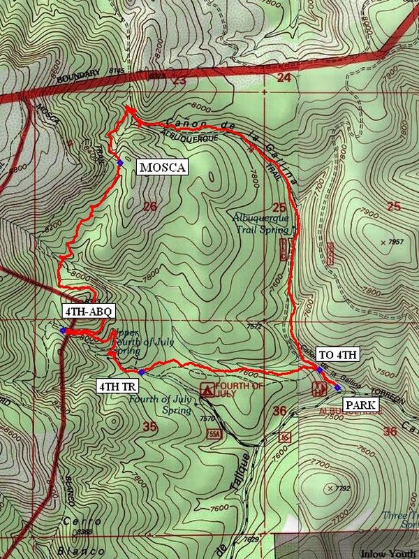
The trail starts at the north end of parking. Hike out to a sign that says 4th of July Canyon Tr. Spur (TO 4TH (0.1 mi)). Go left there and in a mile you will come to 4th of July Canyon Tr (4TH TR (1.0)). Follow it out to the intersection 4TH-ABQ (1.6 mi) where you turn right onto the Albuquerque Trail. Continue north on the Albuquerque Trail past the intersection with the MOSCA (3.0 mi) Trail. You’ll make a right turn on the Albuquerque Trail and head east and then south back to the vehicle at the Albuquerque Tr. Trailhead.
Waypoints
PARK: N34 47.614, W106 22.357
TO 4TH: N34 47.684, W106 22.439
4TH TR: N34 47.675, W106 23.256
4TH-ABQ: N34 47.834, W106 23.619
MOSCA: N34 48.468, W106 23.354
Hike GPS File Name: 4thofJuly-AlbuquerqueTrailLoopShortWayTrack_MW(1).gpx
Hike GPS File: Click link to download hike waytrack file
Text Author: Roger Holloway
Map Author: Marilyn Warrant
Waypoints Author: Dick Brown
Track Author: Dick Brown
Maintainer: Marilyn Warrant
Editor: Howard Carr