Challenge – Rocky Point – Klaus Trails Hike
In Sandia Mountain East Region
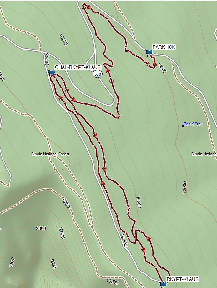
Map File Source: Garmin BaseCamp
 Hike Key: H10737
Last Updated: 06/11/2024 2:25pm
Last Updated By: Marilyn Fixer
Hike Class: C (Challenging)
Hike Distance: 3.8 mi
Minimum Elevation: 9970 ft
Elevation Change: 330 ft
Total Uphill: 730 ft
Total Downhill: 730 ft
Avg. Grade: 3 %
Route Type: CW Loop
On Trail: Yes
Paved or Gravel Roads: Yes
GPS Advised: No
Drive Distance Round Trip: 60 mi
Drive Time One-Way: 1:00
Hiking Seasons: Summer and Fall
New Mexico Game Unit: 8
Hike Status: In Process
Attractions: Forest
Highlights
In the shade so cool on a hot day.
CautionsNone.
Trailhead DirectionsFrom Albuquerque take I-40 east to Tijeras exit. North on NM 14, west on Crest Road SR-536. Park at the 10K Trailhead turnoff on the left just past mile marker 10.
Actual HikeThe hike starts on the 10K Trail at the southeast (downhill) end of the parking lot. Almost immediately take the right fork (the left fork is the southbound 10K Trail). A few meters later, take the right fork again. From there it’s about a mile to the upper end of the Challenge Trail. It has lots of blue diamond markers to keep us on the trail & does follow the road (Hwy 536) closer than the old Challenge Trail but keeps in the shade. Continue to the trailhead for Ellis, Rocky Point and Klaus (CHAL-RKYTP-KLAUS, 1.1 mi).
Both Rocky Point and Klaus start just across from the picnic table where the Service Road ends. (They parallel the Service Road but again in the trees). Take the Rocky Point Trail south until it intersects with the Service Road at the storage sheds belonging to Friends of the Sandias (RKYPT-KLAUS, 1.9 mi). Turn around here and return north on the Klaus Trail to the picnic table starting point intersection (CHAL-RKYPT-KLAUS, 2.7 mi). Return on the Challenge Trail to the parking area.
WaypointsPARK-10K: N35 12.557, W106 26.094
CHAL-RKYPT-KLAUS: N35 12.504, W106 26.413
RKYPT-KLAUS: N35 11.945, W106 26.048
Hike GPS File Name: Challenge-RockyPoint-Klaus_MW3
Hike GPS File: Click link to download hike waytrack file
Text Author: Meg AdamsCameron
Map Author: Marilyn Warrant
Waypoints Author: Marilyn Warrant
Track Author: Marilyn Warrant
Maintainer: Not Assigned
Editor: Marilyn Warrant