Ellis – 10K – Del Agua Overlook-Survey Hike
In Sandia Mountain East Region
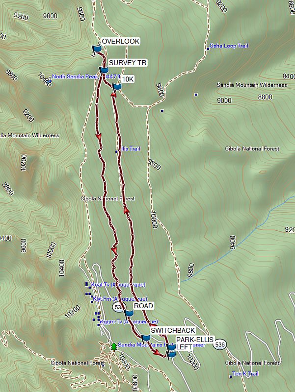
Map File Source: Garmin BaseCamp
 Hike Key: H10736
Last Updated: 06/11/2024 2:27pm
Last Updated By: Marilyn Fixer
Hike Class: C (Challenging)
Hike Distance: 4.9 mi
Minimum Elevation: 9846 ft
Elevation Change: 581 ft
Total Uphill: 1050 ft
Total Downhill: 1050 ft
Avg. Grade: 7 %
Route Type: CCW Loop
On Trail: Yes
Paved or Gravel Roads: Yes
GPS Advised: No
Hiker Limit (NF/BLM/NP): 15 (Sandia Wilderness)
Drive Distance Round Trip: 60 mi
Drive Time One-Way: 1:00
Hiking Seasons: Spring, Summer, and Fall
New Mexico Game Unit:
Hike Status: In Process
Attractions: Fall Color, Forest, Views, and Wildflowers
Highlights
Nice views to east. Good hike for wildflowers and butterflies. Return trail nicely shaded.
CautionsNone.
Trailhead DirectionsFrom Albuquerque go east on I-40 to the SR 14 exit and go north to Cedar Crest. At SR 536 turn left and go up the crest road 11.7 miles to the Ellis Trailhead. PARK on your left. A three dollar fee or Golden Age Pass is required.
Actual HikeFrom PARK go north, crossing the highway. The hike follows the cutting for a road intended to go to the Sandia North Peak area. The road was never completed. The trail intersects the 10K TRAIL (2.0 mi) after up and down travel. Turn left onto the 10K trail which goes up to the intersection with the SURVEY trail (2.2 mi). Continue on a short distance to the del Agua OVERLOOK (2.4 mi). After spending time enjoying the view (also a good lunch spot), return to the SURVEY trail (2.6 mi) intersection and go south. This trail gains elevation at a moderate rate and reaches the state ROAD (4.4 mi). The trail officially ends here. Cross the highway and go downhill on the trail. The SWITCHBACK (4.6 mi) trail joins from the right. Go straight; this is now the Switchback Trail. At LEFT (4.8 mi), leave the Switchback Trail. Arrive at the service road and go left to the parking lot.
WaypointsPARK-ELLIS: N35 12.526, W106 26.419
10K TRAIL: N35 14.053, W106 26.817
SURVEY TR: N35 14.151, W106 26.945
OVERLOOK: N35 14.273, W106 26.963
ROAD: N35 12.723, W106 26.728
SWITCHBACK: N35 12.579, W106 26.604
LEFT: N35 12.483, W106 26.421
Hike GPS File Name: Ellis-10K-DelAguaOverlook-Survey_MW.gpx
Hike GPS File: Click link to download hike waytrack file
Text Author: Dick Brown
Map Author: Marilyn Warrant
Waypoints Author: Dick Brown
Track Author: Dick Brown
Maintainer: Marilyn Warrant
Editor: