La Vega Meadow Hike
In Sangre De Cristos Region
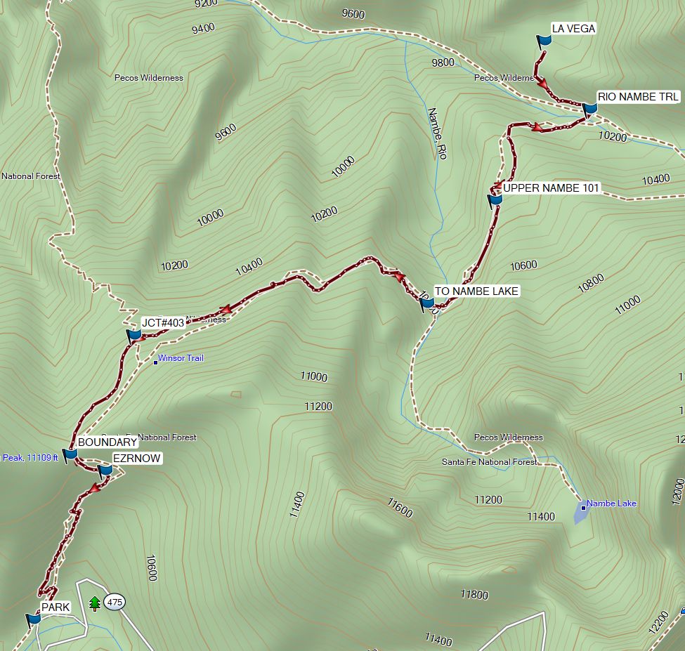
Map File Source: Garmin BaseCamp
 Hike Key: H10711
Last Updated: 03/02/2024 12:58pm
Last Updated By: Marilyn Warrant
Hike Class: D (Difficult)
Hike Distance: 7 mi
Minimum Elevation: 10100 ft
Elevation Change: 750 ft
Total Uphill: 1700 ft
Total Downhill: 1700 ft
Avg. Grade: 7 %
Route Type: InOut
On Trail: Yes
Paved or Gravel Roads: Yes
GPS Advised: Yes
Hiker Limit (NF/BLM/NP): 15 (Pecos Wilderness)
Drive Distance Round Trip: 150 mi
Drive Time One-Way: 1:45
Hiking Seasons: Summer and Fall
New Mexico Game Unit:
Hike Status: In Process
Attractions: Fall Color, Forest, Meadows, Water Features, and Wildflowers
Highlights
A hike through forest to a meadow with wildflowers in season.
CautionsThe elevation of the hike is over 10,000 ft. There are two crossings of the Rio Nambe on large rocks or tree poles laid across the stream. Water shoes are recommended for lower water days.
Trailhead DirectionsThere are several ways to get to Hyde Park Rd (NM 475). One way: From Albuquerque take I-25 north to Santa Fe and take exit #284 north on Old Pecos Trail, which after about 3 miles becomes Old Santa Fe Trail, then turn right (east) on Paseo de Peralta. This street soon curves north and crosses the Santa Fe River where you turn right (east) on East Alameda St. Continue east about .75 mile and turn left (northeast) onto Gonzales Rd. Drive northeast just over 1 mile to Hyde Park Rd (NM 475) and turn right and drive about 14 miles to the Ski Area parking. PARK (0.0 mi) is on the northwest side near the privy and the trail information display board.
Actual HikeThis hike is described in “Day Hikes in the Santa Fe Area”, Eighth Edition, p. 197.
WaypointsPARK: N35 47.741, W105 48.259
EZRNOW: N35 48.108, W105 48.036 (0.7)
BOUNDARY: N35 48.149, W105 48.146 (0.8)
JCT#403: N35 48.443, W105 47.949 (1.2)
TO NAMBE LAKE: N35 48.522, W105 47.046 (2.2)
UPPER NAMBE 130: N35 48.776 W105 46.838 (2.6)
RIO NAMBE 160: N35 49.000, W105 46.546 (3.2)
LA VEGA: N35 49.171, W105 46.687 (3.5)
Hike GPS File Name: WinsorTrlToLaVega_MW.gpx
Hike GPS File: Click link to download hike waytrack file
Text Author: Marilyn Warrant
Map Author: Marilyn Warrant
Waypoints Author: Marilyn Warrant
Track Author: Marilyn Warrant
Maintainer: Carl Gervais
Editor: Randy Simons