Alameda Open Space North Hike
In Albuquerque Region
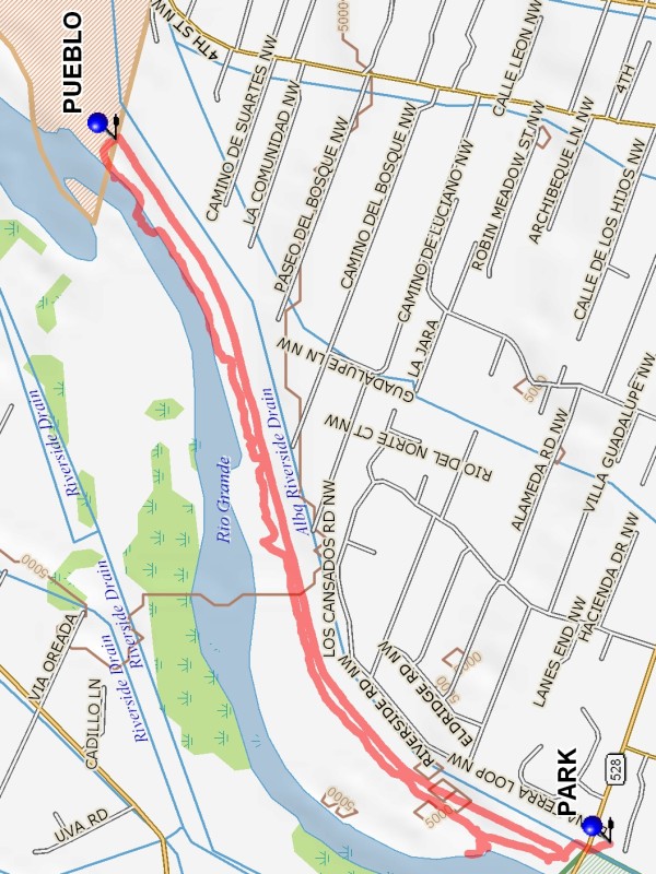
Map File Source: DeLorme
 Hike Key: H10260
Last Updated: 11/21/2024 12:57pm
Last Updated By: Marilyn Fixer
Hike Class: A (Easy)
Hike Distance: 3.9 mi
Minimum Elevation: 4995 ft
Elevation Change: 15 ft
Total Uphill: 15 ft
Total Downhill: 15 ft
Avg. Grade: 0 %
Route Type: CCW Loop
On Trail: Yes
Paved or Gravel Roads: Yes
GPS Advised: No
Drive Distance Round Trip: 20 mi
Drive Time One-Way: 0:30
Hiking Seasons: Spring, Fall, and Winter
New Mexico Game Unit: 9
Hike Status: Published
Attractions: Fall Color and Water Features
Highlights
The Rio Grande, various birds and other wildlife, and North Valley horse stables, homes, and mansions.
Trailhead DirectionsTake Alameda West from I-25 or 4th Street past Rio Grande Blvd. to the Alameda/Rio Grande open space parking lot on the South side of Alameda and PARK (0.0 mi).
Actual HikeThis is a short, level hike in the Bosque and along the levy north of Alameda. It is on the East side of the Rio Grande. The hike starts in the parking lot (with porta-potties) proceeds to the north under Alameda and then west a short distance to the picnic area (before crossing the river). Hike North through the picnic area and enter the Rio Grande State Park. Follow the trail, in the Bosque and along the river, until you come to the Sandia Pueblo fence at PUEBLO (1.7 mi) (clearly marked). Hike east about 100 yards along the pueblo fence and up on the levee. Follow the road atop the levee back to the trail head.
CommentsWe will see the river, Canada geese, sand hill cranes, and North Valley horse stables, homes, and mansions. We may see bald and golden eagles, other birds, coyotes, raccoons, horses, and a few other hikers. Because this is a short, local hike, we will NOT have lunch on the trail. Just bring water and a snack. We will stop for an early lunch at a near-by restaurant.
WaypointsPARK: N 35 11.713, W 106 38.414
PUEBLO: N 35 12.529, W 106 36.994
Hike GPS File Name: AlamedaOpenSpaceNorthWayTrack_DBDB.gpx
Hike GPS File: Click link to download hike waytrack file
Text Author: John Holmes
Map Author: Marilyn Warrant
Waypoints Author: Dick Brown
Track Author: Dick Brown
Maintainer: Not Assigned
Editor: Marilyn Warrant