San Lorenzo Side Canyon Hike
In Socorro Region
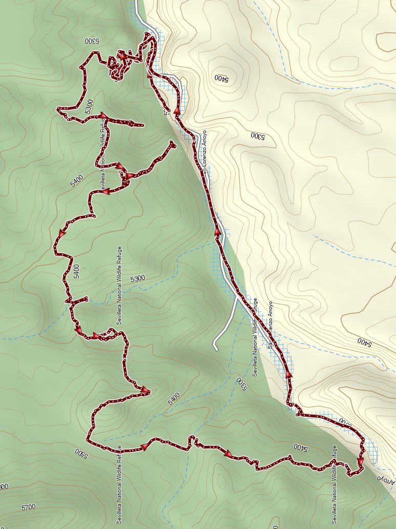
Map File Source: Garmin BaseCamp
 Hike Key: H10705
Last Updated: 09/05/2023 3:32pm
Last Updated By: Marilyn Warrant
Hike Class: D (Difficult)
Hike Distance: 5.5 mi
Minimum Elevation: 5157 ft
Elevation Change: 400 ft
Total Uphill: 1040 ft
Total Downhill: 1040 ft
Avg. Grade: 8 %
Route Type: Loop
On Trail: No
Paved or Gravel Roads: No
GPS Advised: Yes
Drive Distance Round Trip: 140 mi
Drive Time One-Way: 1:30
Hiking Seasons: Spring, Fall, and Winter
New Mexico Game Unit: 13
Hike Status: In Process
Attractions: Arroyos and Rock Formations
Highlights
Box Canyon and amazing views.
CautionsPoles may be useful. There is serious rock scramble to get on the trail and an off-trail steep descent.
Trailhead DirectionsFrom Albuquerque take I-25 South to exit 163, San Acacia. Go east to the frontage road and go south 2.2 miles and turn right onto a paved road which goes under I-25. After passing through the tunnel stay straight onto a dirt road. Go for 2 miles to a small sign on the right “San Lorenzo Canyon” and turn right. After a short distance the road curves to the left and heads west. Go about 3.3 miles to the canyon barrier and PARK (0.0 mi).
Actual HikeFind a way up through the slot-canyon on left side of the canyon. Go up the main canyon to EXIT WASH LEFT (0.6 mi). Follow trail up side of a hill on the left. Follow the trail to VIEWPOINT1 (0.8mi). Retrace the trail up the spine of the hill on the left to the next VIEWPOINT (1.2mi). Follow the trail to the LEAVE TRL SLC LEFT (1.6mi) Scramble down to the LUNCH SPOT Red Rocks (2.0mi). Find trail just up from LUNCH. Follow trail over hill and around to SIDE CANYON Turn a sharp left and follow a faint roadbed downward until you enter a SIDE CANYON (3.2 mi). Go left down the side canyon until it meets the main canyon and then go right. Then proceed back down the main canyon to the barrier and parking.
CommentsThe hike is D level due to some rock scrambling and steep, off trail descent.
Map Filename: SanLorenzoSideCanyon_MW.jpgHike GPS File Name: SAN LORENZO SLOT 2020.gpx
Hike GPS File: Click link to download hike waytrack file
Text Author: Carl Gervais
Map Author: Carl Gervais
Waypoints Author:
Track Author: Carl Gervais
Maintainer: Carl Gervais
Editor: Marilyn Warrant