Tecolote – Balsam Glade – Capulin Hike
In Sandia Mountain East Region
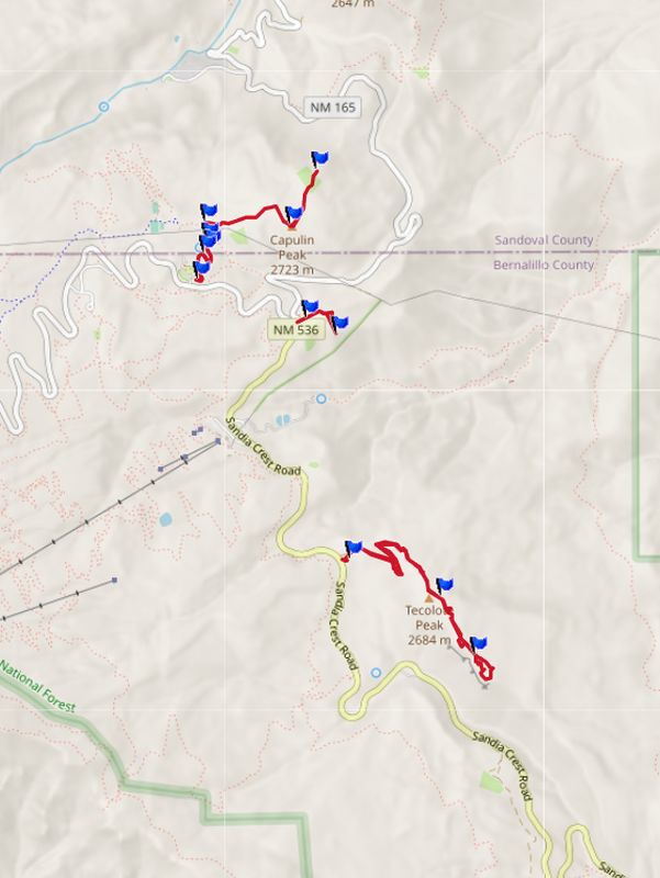
Map File Source: GPS Visualizer
 Hike Key: H10585
Last Updated: 02/28/2024 12:05pm
Last Updated By: Marilyn Warrant
Hike Class: C (Challenging)
Hike Distance: 5.1 mi
Minimum Elevation: 8635 ft
Elevation Change: 381 ft
Total Uphill: 785 ft
Total Downhill: 785 ft
Avg. Grade: 6 %
Route Type: Multiple Hikes
On Trail: Yes
Paved or Gravel Roads: Yes
GPS Advised: Yes
Drive Distance Round Trip: 60 mi
Drive Time One-Way: 0:45
Hiking Seasons: Spring, Summer, and Fall
New Mexico Game Unit: 8
Hike Status: Published
Attractions: Fall Color, Forest, Views, and Wildflowers
Highlights
A combination of three short hikes. Terrific views and abundant wildflowers in season.
CautionsNone.
Trailhead Directions(1) To the Tecolote trailhead, drive to Cedar Crest and then left onto the SR 536 (Sandia Crest Scenic Byway). After Doc Long and milepost 5 you’ll find Tree Springs on the left. Look over to the right and that is Tecolote Peak. Go about a half a mile more and turn right just after milepost 6. (2) Load up the hikers and take a right and continue up the road about 1.4 mi to Balsam Glade and park for lunch. (3) Load up the hikers again, take a right, and continue up the road about 0.5 mi to the Capulin parking area.
Actual Hike(1) Do the Tecolote Peak hike. (2) After lunch at Balsam Glade, hike the short distance to the Madera overlook. (3) Do the Capulin Spring-Capulin Peak-Overlook hike.
CommentsAn option is to hike from Balsam Glade to join the Capulin Peak trail that involves some road walking in the sun. It increases the hike length by about 0.5 mi and the total uphill by about 200 ft.
The hike data were derived from the NG Topo software values for each of the three hikes.
WaypointsPARK-TECOLOTE: N35 12.016 W106, 24.297
PARK-BALSAM: N35 12.827, W106 24.482
PARK-CAPULIN: N35 12.956, W106 24.929
Hike GPS File Name: Tecolote-BalsamGlade-Capulin_WayTrack_MW.gpx
Hike GPS File: Click link to download hike waytrack file
Text Author: Cindy McConnell
Map Author: Marilyn Warrant
Waypoints Author: Marilyn Warrant
Track Author: Marilyn Warrant
Maintainer: Marilyn Warrant
Editor: Marilyn Warrant