Bosque North from I-25 Hike
In Los Lunas Region
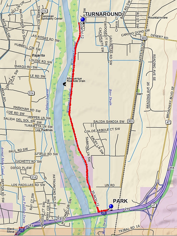
Map File Source: DeLorme
 Hike Key: H10502
Last Updated: 12/15/2020 12:00am
Last Updated By: Marilyn Warrant
Hike Class: B (Moderate)
Hike Distance: 6.4 mi
Minimum Elevation: 4902 ft
Elevation Change: 19 ft
Total Uphill: 19 ft
Total Downhill: 19 ft
Avg. Grade: %
Route Type: InOut
On Trail:
Paved or Gravel Roads:
GPS Advised:
Drive Distance Round Trip: 25 mi
Drive Time One-Way: 0:30
Hiking Seasons: Fall and Winter
New Mexico Game Unit: 9
Hike Status: Inactive
Highlights
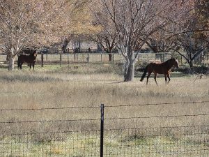
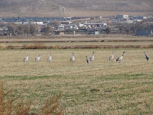
This is a great fall and winter hike to observe migrating cranes and geese, as well as domestic animals in the pastures.
CautionsNone.
Trailhead DirectionsI-25 south to Rio Bravo Exit. Drive west to 2nd Street and then turn left and go south to the end of the paved road. Turn right and go west on the dirt road to the ditch. At the ditch, turn left and follow the dirt road along the east side of the ditch to the end and park.
Actual HikeFrom PARK (0.0) head west along the south side of the smaller ditch. Turn right at the larger ditch and proceed north along the east side of this ditch to TURNAROUND (3.2). Return the way you came.
CommentsThis is a great fall and winter hike when all the birds have migrated here.
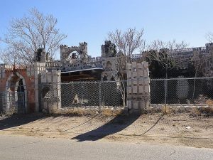
We have seen hundreds of cranes and geese in addition to red tailed hawks, crows, etc. in the many pastures. Also you can see many domestic animals (horses, goats and others). A castle next to 2nd Street South of the Tijeras Arroyo can be seen going to and from the hike. This castle/house belongs to or used to belong to Manny Aragon.
Hike altered and renamed Valle de Oro.
WaypointsPARK: N34 57.082, W106 40.485
TURNAROUND: N34 59.654, W106 40.961
Hike GPS File Name: BosqueNorthfromI-25WayTrack_FE.gpx
Hike GPS File: Click link to download hike waytrack file
Text Author: Frank Ernst
Map Author: Marilyn Warrant
Waypoints Author: Frank Ernst
Track Author: Frank Ernst
Maintainer: Frank Ernst
Editor: Howard Carr