White Mesa – East Loop Hike
In Ojito Region
Map File Source: DeLorme
 Hike Key: H10245
Last Updated: 02/25/2025 9:40pm
Last Updated By: Marilyn Fixer
Hike Class: C (Challenging)
Hike Distance: 5.1 mi
Minimum Elevation: 5660 ft
Elevation Change: 370 ft
Total Uphill: 713 ft
Total Downhill: 713 ft
Avg. Grade: 7 %
Route Type: Loop
On Trail: No
Paved or Gravel Roads: No
GPS Advised: Yes
Drive Distance Round Trip: 100 mi
Drive Time One-Way: 1:00
Hiking Seasons: Spring, Fall, and Winter
New Mexico Game Unit: 9
Hike Status: Published
Access Description: Ojito Wilderness Area Access
Highlights
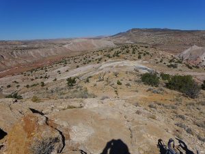
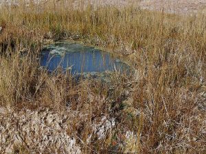
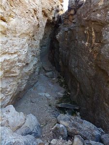
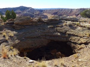
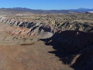
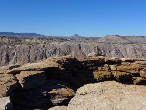
Spectacular canyon views, active seeps, sinkholes, and an optional visit to the “Candle Cave.”
CautionsSome steep sections, so hiking poles are helpful.
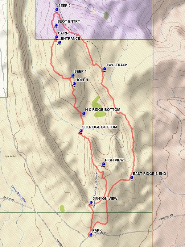
Trailhead DirectionsFrom Albuquerque go north on I-25, then from Bernalillo go northwest on US-550 for 20.9 miles. Turn left on Cabezon Road, about 2 miles before San Ysidro. Almost immediately there is a Y in the road, go left. At 4.5 miles, on the first downhill in the Ojito Wilderness, there will be a parking area on the right. PARK (0.0 mi) here.
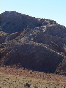
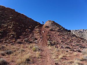
Actual HikeGo north through the pass on the two track. After a short distance, take a track bearing uphill to the left, which joins a road which passes through some old diggings for gypsum. The hike loops starts at the spectacular CANYON VIEW (0.3 mi). Go to the east side of the canyon but do not try to stay near the edge, and find a road which bears north toward a white peak. At the peak one can ascend if desired for a good view of the area. The Nacimiento uplift, the beginning of the Jemez Mountain area, stretches to the north. To the east is “White Mesa”, an extensive gypsum quarry. To continue, find a trail on the west side of the peak which will go north down the central spine to the S C RIDGE BOTTOM (1.2 mi). A path runs north across the flat bottom to the N C RIDGE BOTTOM (1.4 mi) where a road goes up the north central ridge. Near the top climb the small peak to view HOLE 1 (1.7 mi). This is a collapsed seep (sipapu). Go down the north side of the peak to an active SEEP 1 (1.8 mi). If desired, you can visit the Candle Cave. At the CAIRN (2.3 mi), turn southeast (sharp right), and walk a short distance to the cave ENTRANCE. Light a candle or two, if you wish, and sign the visitor book. Beyond this point there is a large crack in the ridge. Examine this crack if desired, but stay on the west side of the crack. Go north along the west side of the ridge and find the mouth of the crack. Then continue north to a hole beyond which there is another active SEEP 2 (2.5 mi). Then go east, dropping down onto a road and turn south on that road and shortly reach a split. Stay left toward the east ridge and go onto the bike path which runs south near the west edge of the ridge, affording good views to the west into the canyon. On reaching the EAST RIDGE S END (4.4 mi) turn west and follow the road which turns south and then west near parking.
CommentsThe hike can be done in the clockwise direction. This would involve going up the center spine, the most difficult grade on the hike. The BLM calls this area Ojito Bike Trails as White Mesa is actually to the east.
WaypointsHIGH VIEW: N 35 30.427, W 106 50.371
PARK: N 35 29.907, W 106 50.486
CANYON VIEW: N 35 30.143, W 106 50.486
S C RIDGE BOTTOM: N 35 30.670, W 106 50.577
N C RIDGE BOTTOM: N 35 30.800, W 106 50.552
HOLE 1: N 35 31.019, W 106 50.638
SEEP 1: N 35 31.083, W 106 50.650
CAIRN: N35 31.365, W106 50.799
ENTRANCE: N35 31.326, W106 50.771
SLOT ENTRY: N 35 31.452, W 106 50.804
SEEP 2: N 35 31.568, W 106 50.798
TWO TRACK: N 35 31.129, W 106 50.362
EAST RIDGE S END: N 35 30.326, W 106 50.116
Hike GPS File Name: WhiteMesa-EastLoopWayTrack_DBDB.gpx
Hike GPS File: Click link to download hike waytrack file
Text Author: Dick Brown
Map Author: Dick Brown
Waypoints Author: Dick Brown
Track Author: Dick Brown
Maintainer: Not Assigned
Editor: Marilyn Warrant