La Mesita Blanca – Big Arroyo Loop Hike
In Tohajillee Region
Map File Source: NG Topo
 Hike Key: H10239
Last Updated: 12/15/2020 12:00am
Last Updated By: Marilyn Warrant
Hike Class: C (Challenging)
Hike Distance: 5.5 mi
Minimum Elevation: 5805 ft
Elevation Change: 360 ft
Total Uphill: 765 ft
Total Downhill: 765 ft
Avg. Grade: 4 %
Route Type: CCW Loop
On Trail: No
Paved or Gravel Roads: No
GPS Advised: Yes
Drive Distance Round Trip: 90 mi
Drive Time One-Way: 1:00
Hiking Seasons: Spring, Fall, and Winter
New Mexico Game Unit: 9
Hike Status: Published
Highlights
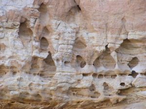
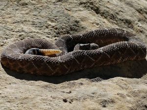
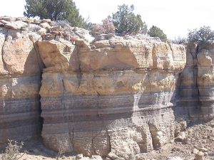
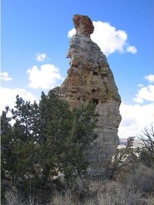
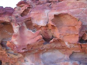
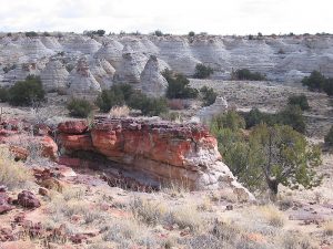
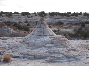
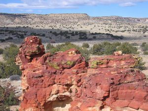
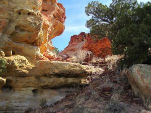
Red and yellow rock formations, huge white sandstone beehive domes, far mountain views and a surprise band of fossils in the big arroyo portion of the hike.
CautionsWalking off trail in soft sand with many cactus; climb down pour-offs with convenient steps. Hiking sticks will help with stability. (Don’t want to fall in the cactus!)
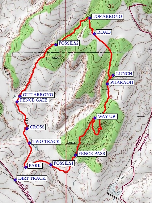
Trailhead DirectionsI-40 west to Tohajillee exit-131. Go north towards the village. Just before the school area, turn right over a CATTLE GUARD with yellow sides (7.8 mi from I-40 interchange). Then take an immediate left onto BIA-56. Drive for approx. 8 mi., taking the obvious main road at any turns. At “T” with another main road, go left for about 0.5 mi and look for a DIRT TRACK on the right that goes off towards a red rock area across the arroyo. Drive as far as you dare and PARK (0.0 mi).
Actual HikeBegin by heading towards the reddish rock shapes off to the east, across a small arroyo. When you get to the arroyo, take time to go a little down to right and look for many FOSSILS1 (0.3 mi) embedded in the sandstone. Then find the WAY UP (1.4 mi) to a mesa with views of the shapes and spires to the east. Wander around up toward PHARAOH (2.4 mi) rock and then over to another red rock formation for LUNCH. Keep going generally north then northwest to reach the beginning of a long, slick-rock arroyo (waypoint TOP ARROYO (3.3 mi)) that leads back in a southwest direction. Locate the band of fossils in the right-hand-side arroyo wall at FOSSILS2 (3.9 mi). Get OUT ARROYO (4.6 mi) and through a FENCE GATE (4.8 mi). Follow cow tracks when you can and CROSS (5.0 mi) the deep gulley to get on its west side. Meet up with a TWO TRACK (5.3 mi) and go over a couple of rises to where you parked.
CommentsThe hike class has been raised to “C” due to the long walk on cactus-covered ground and uneven footing in the arroyo.
The hike data were determined from a track recorded by a Garmin GPSMap 60CSx.
WaypointsAccess:
CATTLE GUARD: N35 05.820, W107 06.662
DIRT TRACK: N35 11.907, W107 06.497
Hike:
PARK: N35 12.025, W107 06.375
FOSSILS1: N35 12.049, W107 06.086
FENCE PASS: N35 12.141, W107 05.800
WAY UP: N35 12.492, W107 05.572
PHARAOH: N35 12.816, W107 05.432
LUNCH: N35 12.897, W107 05.361
ROAD: N35 13.289, W107 05.582
TOP ARROYO: N35 13.440, W107 05.633
FOSSILS2: N35 13.186, W107 06.027
OUT ARROYO: N35 12.699, W107 06.442
FENCE GATE: N35 12.647, W107 06.474
CROSS: N35 12.394, W107 06.360
TWO TRACK: N35 12.254, W107 06.331
Hike GPS File Name: LaMesitaBlanca-BigArroyo500-1_MW.gpx
Hike GPS File: Click link to download hike waytrack file
Additional File 1 Link Click link to download an additional file.
Text Author: Frances Arnold
Map Author: Marilyn Warrant
Waypoints Author: Marilyn Warrant
Track Author: Marilyn Warrant
Maintainer: Marilyn Warrant
Editor: Dawn McIntyre