Barley Canyon Hike
In Jemez Mountains Region
Map File Source: DeLorme
 Hike Key: H10224
Last Updated: 12/15/2020 12:00am
Last Updated By: Marilyn Warrant
Hike Class: C (Challenging)
Hike Distance: 5.8 mi
Minimum Elevation: 7925 ft
Elevation Change: 775 ft
Total Uphill: 809 ft
Total Downhill: 809 ft
Avg. Grade: 7 %
Route Type: InOut
On Trail: Yes
Paved or Gravel Roads: Yes
GPS Advised: No
Drive Distance Round Trip: 160 mi
Drive Time One-Way: 1:45
Hiking Seasons: Spring, Summer, and Fall
New Mexico Game Unit: 6A
Hike Status: Published
Highlights
Pleasant stroll up a canyon. Great aspen color in the fall.
CautionsNone.
Trailhead DirectionsFrom Albuquerque take I-25 north to Bernalillo. From Bernalillo take US 550 to San Ysidro. Take SR 4 north to La Cueva. Go east on SR 126 to Fenton lake. Proceed beyond the “Bridge” for about .5 miles and TURN right onto a forest road. Go about a mile on the road and PARK (0.0 mi).
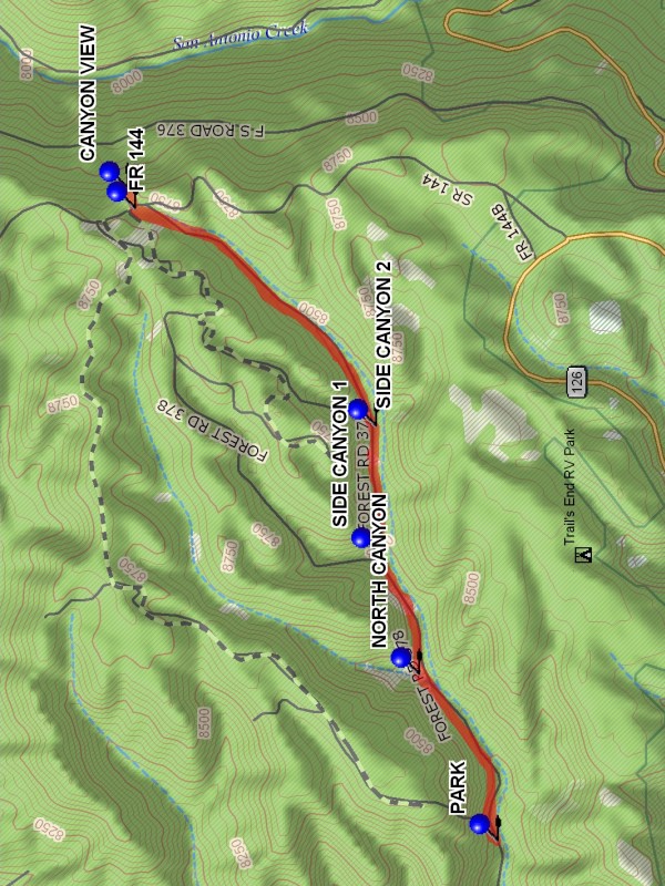
Actual HikeThe hike is on a two track dirt road, FR 378 and ends at FR 144 on the west ridge of San Antonio canyon. There is somewhat of a CANYON VIEW (2.9 mi) at that point, so have lunch there. Return back down along the same road.
WaypointsTURN: N35 53.481, W106 43.220
PARK: N35 53.608, W106 42.291
SIDE CANYON 1: N35 53.967, W106 41.216
SIDE CANYON 2: N35 53.979, W106 40.732
FR 144: N35 54.712, W106 39.912
CANYON VIEW: N35 54.736, W106 39.837
NORTH CANYON: N35 53.847, W106 41.665
Hike GPS File Name: BarleyCanyonWayTrack_DBDB.gpx
Hike GPS File: Click link to download hike waytrack file
Text Author: Dick Brown
Map Author: Marilyn Warrant
Waypoints Author: Dick Brown
Track Author: Dick Brown
Maintainer: Not Assigned
Editor: Howard Carr