Bear Wallow – Borrego Loop Hike
In Sangre De Cristos Region
Map File Source: DeLorme
 Hike Key: H10222
Last Updated: 12/15/2020 12:00am
Last Updated By: Marilyn Warrant
Hike Class: C (Challenging)
Hike Distance: 3.9 mi
Minimum Elevation: 8238 ft
Elevation Change: 653 ft
Total Uphill: 860 ft
Total Downhill: 860 ft
Avg. Grade: 9 %
Route Type: CW Loop
On Trail: Yes
Paved or Gravel Roads: Yes
GPS Advised: No
Drive Distance Round Trip: 140 mi
Drive Time One-Way: 1:30
Hiking Seasons: Spring, Summer, and Fall
New Mexico Game Unit: 44
Hike Status: Published
Highlights
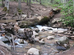
Mountain stream; dense forest. Some fun stream crossings over logs for the adventuresome.
CautionsTrekking poles recommended.
Trailhead DirectionsTake I-25 north to Santa Fe. Take the Old Pecos Trail exit 284 and follow to Paseo de Peralta. Turn right and follow to Washington Avenue, just before the pink Masonic Temple. Turn north on Washington, then east on Artist Road, which becomes Hyde Park Rd. Follow it past Chamisa trailhead, milepost 8, entrance sign to Hyde Memorial State Park, Visitor’s Center and Lodge, mp 9, almost up to top of hill and park at left just before sign “Leaving Hyde State Park.” This is the PARK (0.0 mi) area for the trailhead (Borrego Tr.).
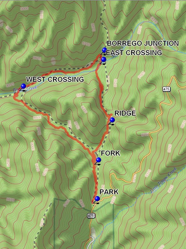
Actual HikeFollow the trail down to the signpost. Bear Wallow Trail goes off to the left, whereas Borrego goes straight ahead. The hike is a triangle composed of trails 182 to the left, 264 and 160 coming back on the right (clockwise). When you start off down the trail you will come to an immediate fork or two. Always take the most traveled going down canyon. You will come to a nasty toilet on the left and a water tub on the right. Follow Bear Wallow Tr. 182 left at signpost and FORK (0.3 mi), down canyon to 3 switchbacks before coming to Tesuque Creek at the WEST CROSSING (1.5 mi). Cross on a nasty log. Follow Winsor Trail upstream along the north side of the Creek to another fork at the BORREGO JUNCTION (2.3 mi). Go right on Borrego (lamb) Tr. 150 which heads back to the creek. Have lunch there in a nice meadow by the log EAST CROSSING (2.4 mi). There are nice small waterfalls to the left of the crossing. Follow Borrego Tr. 150 up to top of the RIDGE (3.2 mi) and down to close the loop at junction with Bear Wallow Tr. and return to trailhead.
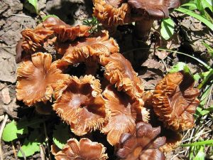
CommentsA beautiful place of tall aspens and pines.
WaypointsPARK: N35 44.792, W105 50.058
FORK: N35 45.081, W105 50.046
WEST CROSSING: N35 45.628, W105 50.737
BORREGO JUNCTION: N35 45.897, W105 49.991
EAST CROSSING: N35 45.827, W105 49.999
RIDGE: N35 45.377, W105 49.920
Hike GPS File Name: BearWallow-BorregoLoopWayTrack_DBDB.gpx
Hike GPS File: Click link to download hike waytrack file
Text Author: Roger Holloway
Map Author: Marilyn Warrant
Waypoints Author: Dick Brown
Track Author: Dick Brown
Maintainer: Not Assigned
Editor: Marilyn Warrant