Strip Mine Loop Hike
In Placitas Region
Map File Source: NG Topo
 Hike Key: H10221
Last Updated: 03/20/2023 2:40pm
Last Updated By: Marilyn Fixer
Hike Class: C (Challenging)
Hike Distance: 5.4 mi
Minimum Elevation: 5657 ft
Elevation Change: 776 ft
Total Uphill: 860 ft
Total Downhill: 860 ft
Avg. Grade: 7 %
Route Type: Loop
On Trail: Yes
Paved or Gravel Roads: Yes
GPS Advised: No
Hiker Limit (NF/BLM/NP): 15 (Sandia Wilderness)
Drive Distance Round Trip: 45 mi
Drive Time One-Way: 0:45
Hiking Seasons: Spring, Fall, and Winter
New Mexico Game Unit: 8
Hike Status: Published
Highlights
Views of the Sandias, pinon and juniper-covered hills, colorful rock formations, and, far in the distance, the Jemez and Nacimiento Mountains, along with Cabezon and Mount Taylor.
CautionsTrekking poles will help with the steep sections of the downhill trail in the second half of the hike.
Trailhead DirectionsDirections I-25 north to Placitas exit (exit 242). Go east on SR 165 for 3 miles. Just after the mile 3 marker, turn right and drive about 1/2 mile until you see small parking areas on either side of the dirt road. The Strip Mine Trail 51 trailhead is on the left. PARK (0.0 mi) here.
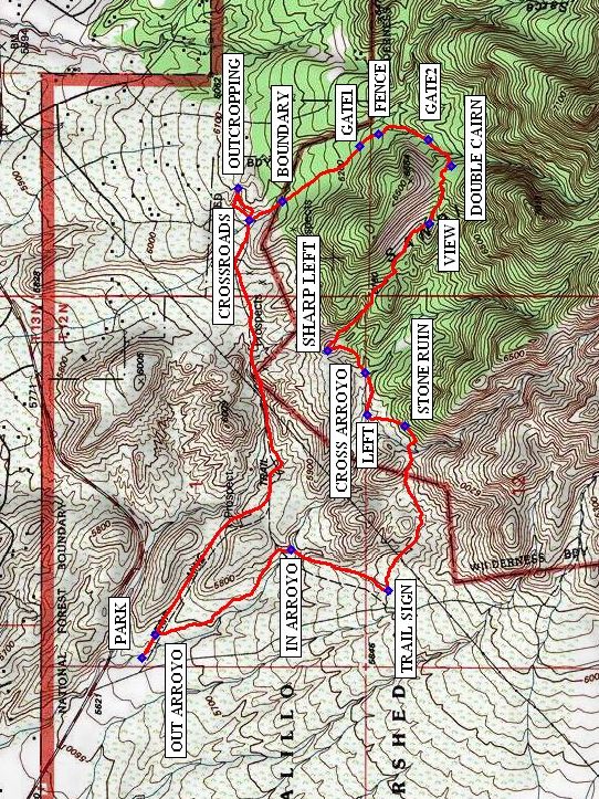
Actual HikeThis hike is a clockwise loop (or a lollipop with a very short “stick”). Hike east until you come to an arroyo where you will go straight ahead across the arroyo. When you come to the CROSSROADS (1.5 mi), go straight (northeast) for a bit, to see the OUTCROPPING (1.6 mi), and return to the CROSSROADS, taking the trail to the southeast. You will pass a BOUNDARY (1.9 mi) sign and go through GATE1 (2.2 mi) and GATE2 (2.5 mi). About 10 feet before reaching the DOUBLE CAIRN (2.6 mi), you will see a cholla cactus in the middle of the trail, surrounded by a ring of rocks. Turn right here and proceed down a long, steep hill until you get to VIEW, where you will stop for lunch. Continue down the hill, taking extra care, as bikers have erected several jumps, and the path is very steep and rocky at times. The trail eventually reaches a crossroads, where you will turn SHARP LEFT (3.4 mi). Continue down this hill until you come to a small, gravelly arroyo, crossing it at CROSS ARROYO (3.5 mi). Continue until you turn at LEFT (3.7 mi). You will then reach STONE RUIN (3.8 mi), where you can speculate about who built this structure and what it was used for. Turn right at the TRAIL SIGN (4.4 mi), not on the road just beyond it. When you reach IN ARROYO (4.7 mi), turn left and hike in the arroyo, until you reach OUT ARROYO (5.3 mi) and the end of the loop. Turn left and proceed back to the van.
CommentsThis hike follows the north foothills of the Sandias east along the edge of some old strip mines. For most of the hike, there are no homes visible, and you can enjoy views of the Sandias, pinon and juniper-covered hills, colorful rock formations, and, far in the distance, the Jemez and Nacimiento Mountains, along with Cabezon and Mount Taylor. The first part of the hike is steadily but not steeply uphill, while the second half is mostly downhill, at times quite steep.
WaypointsPARK: N 35 18.009, W 106 28.832
CROSSROADS: N 35 17.723, W 106 27.414
OUTCROPPING: N 35 17.754, W 106 27.310
BOUNDARY: N 35 17.635, W 106 27.352
GATE1: N 35 17.431, W 106 27.175
FENCE: N 35 17.381, W 106 27.134
GATE2: N 35 17.249, W 106 27.154
DOUBLE CAIRN: N 35 17.188, W 106 27.239
VIEW: N 35 17.246, W 106 27.426
SHARP LEFT: N 35 17.517, W 106 27.835
CROSS ARROYO: N 35 17.416, W 106 27.907
LEFT: N 35 17.410, W 106 28.045
STONE RUIN: N 35 17.311, W 106 28.080
TRAIL SIGN: N 35 17.355, W 106 28.611
IN ARROYO: N 35 17.611, W 106 28.481
OUT ARROYO: N 35 17.973, W 106 28.756
Hike GPS File Name: StripMineLoopWayTrack_MWMW.gpx
Hike GPS File: Click link to download hike waytrack file
Text Author: Bill Davidson
Map Author: Marilyn Warrant
Waypoints Author: Marilyn Warrant
Track Author: Marilyn Warrant
Maintainer: Nancy Carr
Editor: Marilyn Warrant