Cerrillos Hills Historic Park Hike
In Cerrillos Region
Map File Source: NG Topo
 Hike Key: H10154
Last Updated: 03/08/2021 12:00am
Last Updated By: Marilyn Fixer
Hike Class: B (Moderate)
Hike Distance: 4.6 mi
Minimum Elevation: 5700 ft
Elevation Change: 425 ft
Total Uphill: 676 ft
Total Downhill: 676 ft
Avg. Grade: 7 %
Route Type: Loop
On Trail: Yes
Paved or Gravel Roads: Yes
GPS Advised: No
Drive Distance Round Trip: 100 mi
Drive Time One-Way: 1:15
Hiking Seasons: Spring and Fall
New Mexico Game Unit: 8
Hike Status: Published
Highlights
Panoramic views of the Ortiz and Sandia mountains; mineral spring; historical mines. Possible guided tour by Park Ranger.
CautionsMines are deep but sturdy railings around openings; some steep sections; bring trekking poles.
Trailhead DirectionsTHE RELIABLE ROUTE: FROM STATE HIGHWAY 14 TURN WEST INTO THE VILLAGE OF CERRILLOS. AT THE FIRST STOP SIGN, TURN RIGHT (NORTH) ONTO FIRST STREET, CROSS THE RAILROAD TRACKS AND FOLLOW PARK SIGNS. AT THE CATTLE GUARD, VEER LEFT, ONTO COUNTY ROAD 59. THE MAIN PARKING IS ON THE LEFT HAND SIDE ABOUT 1/4 MILE UP THE ROAD.
The Adventurous Route: From I-25 take the Waldo Canyon exit (Exit 267) at the top of La Bajada hill and head south. After 8 miles on unpaved County Road 57, you will arrive in the Village of Cerrillos. Take a left at the railroad intersection and follow park signs. At the cattle guard, veer left onto County Road 59. The main parking is on the left hand side about 1/4 mile up the road. County Road 57 may be impassable during wet weather.
There is a toilet there, too.
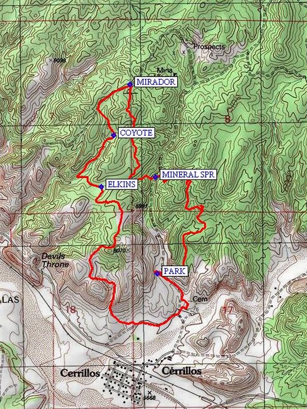
Actual HikeCross the road and go east on the Jane Calvin Sanchez Trail, then north. Take a left (west) on the J. C. Sanchez Trail to the MINERAL SPR (1.2 mi) trailhead, and continue west on the Escalante Trail. The trail turns to the north. Keep going north until you reach the trailhead for the MIRADOR (1.9 mi) Trail. Follow that trail southwest then south as it curves. Where the COYOTE (2.3 mi) Trail intersects, follow the Coyote Trail southwest then southeast, until you come to the intersection with the ELKINS (2.8 mi) Canyon Trail. Go south on that trail. The trail joins the Yerba Buena multi-use roadway and goes east, then heads north to the parking area.
CommentsThis is now a New Mexico State Park. The trails make a loop around sites where there are old mine shafts for turquoise, silver, lead, manganese and other minerals. Many benches along the trails. Good views down onto the village of Cerrillos and on beyond to Madrid. The Ortiz Mountains are south of the “cerrillos” and the Sandias are in the distance. For more information, go to the Cerrillos Hills State Park website. The park ranger will give a guided tour if you make arrangements in advance. Another option at the beginning of the hike is to walk north on the Camino Tuquesa multi-use roadway to the Mineral Spring trailhead.
Note: There is a $15 parking fee and the senior passes DO NOT suffice.
WaypointsPARK: N35 26.695, W106 07.390
MINERAL SPR: N35 27.127, W106 07.399
MIRADOR: N35 27.544, W106 07.539
COYOTE: N35 27.317, W106 07.628
ELKINS: N35 27.086, W106 07.700
Hike GPS File Name: CerrillosHillsHistoricParkWayTrack_JBMW.gpx
Hike GPS File: Click link to download hike waytrack file
Text Author: Roger Holloway
Map Author: Marilyn Warrant
Waypoints Author: Marilyn Warrant
Track Author: John Boyd
Maintainer: Vivian Heyward
Editor: Marilyn Warrant