Beyond Meseta De Ricardo Hike
In Ojito Region
Map File Source: DeLorme
 Hike Key: H10116
Last Updated: 06/11/2024 3:21pm
Last Updated By: Marilyn Fixer
Hike Class: B (Moderate)
Hike Distance: 5.2 mi
Minimum Elevation: 5830 ft
Elevation Change: 200 ft
Total Uphill: 330 ft
Total Downhill: 330 ft
Avg. Grade: 3 %
Route Type: CCW Loop
On Trail: No
Paved or Gravel Roads: No
GPS Advised: Yes
Drive Distance Round Trip: 100 mi
Drive Time One-Way: 1:30
Hiking Seasons: Spring and Fall
New Mexico Game Unit: 9
Hike Status: Published
Access Description: Ojito Wilderness Area Access
Highlights
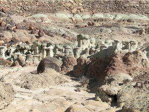
Many sandstone formations and other rocky expanses, mesas and badlands areas. Interesting red cap rock area.
CautionsNone.
Trailhead DirectionsFrom Albuquerque go north to the intersection of I 25 and US 550 (formerly SR 44) in Bernalillo go northwest on US 550 for 20.9 miles to Cabezon Road. This intersection is about 2 miles before San Ysidro. Turn left onto Cabezon Road. Almost immediately there is a Y in the road, go left. At 10.9 miles there is a gas pipeline compression station. Turn right onto Pipeline road, and go 1.4 miles to a small CORRAL on your right. Go right and open the wire gate (close it) and go as far as is comfortable for the driver and park. The furtherest and most difficult drive is to PARK (0.0 mi).
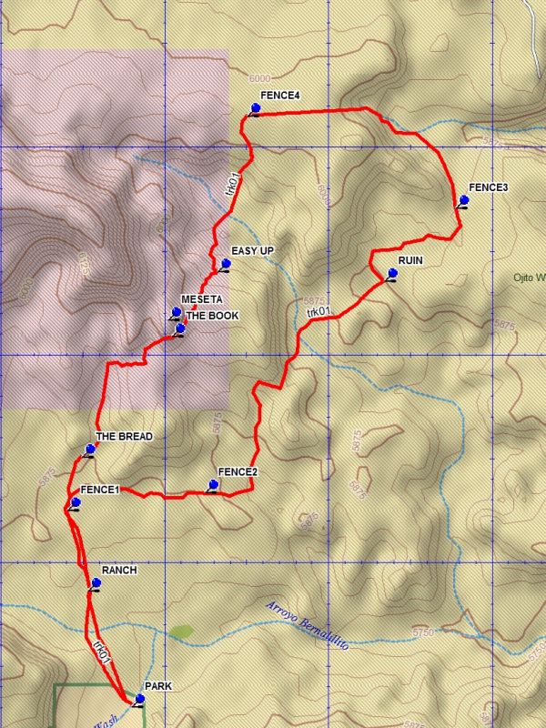
Actual HikeAt PARK (0.0 mi) there is a windmill, old ranch building, and a pass through (open the wire gate) and go through to the other side of the fence. Then go north and visit the ranch ruins after about a quarter of a mile. Then go about two tenths of a mile north to the FENCE1 (0.6 mi) pass through. Go right (east) along the base of the low mesa to the north. There are small badlands formations and interesting rock in this area. After about a half mile FENCE2 (1.0 mi) is crossed. Go up and over the ridge into the arroyo beyond. Go north up the arroyo for about one half mile, where there is a split. Do not go up the canyon to the left. Keep right and continue another half mile. After FENCE3 (2.5 mi) enter the canyon on the left. There are interesting formations in this canyon. Then climb up out of the canyon and go westward along fence 4 for about three tenths of a mile. There will be a break at FENCE4 (3.2 mi), turn south. Shortly there will be the edge of a canyon, a nice spot to sit and have lunch. Then climb down the canyon and go to the other side where there is an easy way EASY UP (3.7 mi) the other side, just find it. This area is the destination of the Mesita de Ricardo hike and the Mesita De Ricardo – Northwest Passage hike. For more information about this area, see the descriptions of these hikes. Proceed toward the base of the small high mesa and down through the rock formation maze and down off the ledge. Proceed back to the FENCE1 crossing and back to parking.
CommentsThis hike is in the Ojito Wilderness Area, wilderness restrictions apply. A loop hike over largely rough and varied terrain. Although the map shows an intrusion into State Land Office land, this section has been transferred to the BLM who manage the Ojito Wilderness Area.
WaypointsCORRAL: N35 30.221, W106 57.393
PARK: N35 30.652, W106 56.603
RANCH: N35 30.933, W106 56.736
FENCE1: N35 31.126, W106 56.797
FENCE2: N35 31.168, W106 56.379
RUIN: N35 31.678, W106 55.830
FENCE3: N35 31.854, W106 55.613
FENCE4: N35 32.077, W106 56.248
EASY UP: N35 31.701, W106 56.340
MESETA: N35 31.585, W106 56.491
THE BOOK: N35 31.545, W106 56.478
THE BREAD: N35 31.255, W106 56.754
Hike GPS File Name: BeyondMesetaDeRicardoWayTrack_DBDB.gpx
Hike GPS File: Click link to download hike waytrack file
Text Author: Dick Brown
Map Author: Dick Brown
Waypoints Author: Dick Brown
Track Author: Dick Brown
Maintainer: Randy Simons
Editor: Howard Carr