Soda Dam Overlook Hike
In Jemez Mountains Region
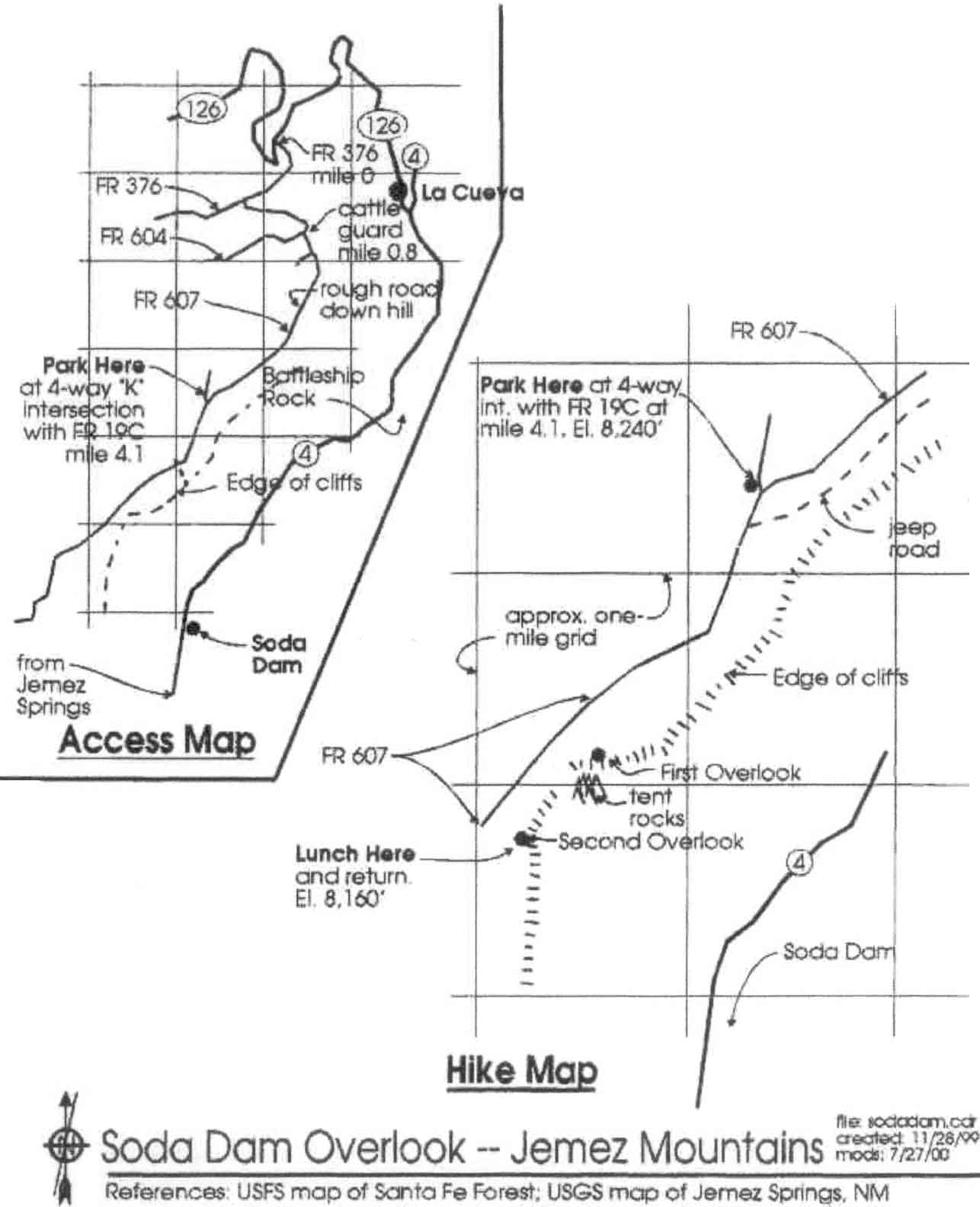
Map File Source: Roger Holloway
 Hike Key: H10084
Last Updated: 02/07/2022 12:00am
Last Updated By: Marilyn Fixer
Hike Class: B (Moderate)
Hike Distance: 4 mi
Minimum Elevation: 8156 ft
Elevation Change: 147 ft
Total Uphill: 383 ft
Total Downhill: 383 ft
Avg. Grade: 4 %
Route Type: InOut
On Trail:
Paved or Gravel Roads:
GPS Advised:
Drive Distance Round Trip: 160 mi
Drive Time One-Way: 2:15
Hiking Seasons: Spring and Fall
New Mexico Game Unit: 6A
Hike Status: Inactive
Highlights
Hike through a grassy meadow with rocky crags on both sides. Views of the entire San Diego Canyon and spectacular tent rocks from the overlook.
CautionsNone.
Trailhead DirectionsDirections: Take SR 126 west from SR 4 at La Cueva 6 mi. to FR 376 near top of long hill. (Check odometer: 4.1 mi. from here to parking.) Left on FR 376 3 min. to a left on FR 604 then, in 4 min., just past cattle guard, take a left on FR 607 (which was unmarked 7/00 — sign said “Latilla Area”). Where there is a minor fork off to the left (follow the main one) the road gets pretty rough – it gets better after the descent. But if wet, start hike at top of hill. If dry continue to four-way “K” intersection with 918C. (An iron gate was closed on 7/00 so we parked there.) Park at (or hike on to) the “K.”
Actual HikeIt takes one hour to walk from locked gate to K intersection and another 25 min. to reach cliff overlook. From the K intersection hike up the left fork. Hike on the road continuing straight ahead and up (don’t go to right on road to steel corral.) At the top there was a sign, 607, in about 8 min. a fence with gate, then in about 6 min. a fork in road. Take right fork. (We took left fork 607B to microwave point) and keep going to the point overlooking the tent rocks. Lunch there with a great view of the San Diego Canyon below. Head back to the road by going straight away from cliffs and return.
CommentsThe hike is through grassy meadow with rocky crags on both sides. The overlook takes in the entire Jemez Canyon, officially known as San Diego (St. James) Canyon. Spectacular tent rocks directly below.
This hike is set Inactive because the access road was blocked by logs when we did an exploratory hike years ago.
WaypointsSoda Dam Inters FR: N35 52.865, W106 39.910
Soda Dam Overlook TH: N35 50.073, W106 40.733
Hike GPS File Name: SodaDamOverlookWayTrack_DBJB.gpx
Hike GPS File: Click link to download hike waytrack file
Text Author: Roger Holloway
Map Author: Roger Holloway
Waypoints Author: John Boyd
Track Author: Dick Brown
Maintainer: Marilyn Warrant
Editor: Marilyn Warrant