Rio Grande Trails from Montano Hike
In Albuquerque Region
Map File Source: Garmin BaseCamp
 Hike Key: H10747
Last Updated: 03/25/2025 4:13pm
Last Updated By: Marilyn Warrant
Hike Class: A (Easy)
Hike Distance: 4 mi
Minimum Elevation: 4860 ft
Elevation Change: 140 ft
Total Uphill: 300 ft
Total Downhill: 300 ft
Avg. Grade: 1 %
Route Type: CW Loop
On Trail: Yes
Paved or Gravel Roads: Yes
GPS Advised: No
Drive Distance Round Trip: 20 mi
Drive Time One-Way: 0:15
Hiking Seasons: Spring, Summer, Fall, and Winter
New Mexico Game Unit: 9
Hike Status: Waiting Editor
Attractions: Views, Water Features, Wildflowers, and Wildlife
Highlights
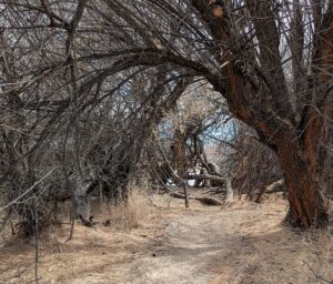
An easy walk along the Rio Grande and the Corrales Drain. You may see ducks, coots, and geese and maybe hear some sandhill cranes flying above.
Trailhead DirectionsGo west on Montgomery, which turns into Montano. Just after crossing the river and before reaching Coors, turn left into the Pueblo Montano Picnic Area parking lot.
Actual HikeDon’t cross the highway! From PARK-MONTANO, go north a short distance, then west past a bench until you come across the tunnel under the highway. Go through it. Go straight to begin with, then GO LEFT (0.2 mi) at the trail intersection onto the sandy Normandy trail (that’s what it’s called on online maps). TURN RT (0.7 mi) at the first major trail crossing and go a short distance to the RIVER TRL (0.9 mi). Go a few steps past that to a narrow trail that goes along the river (and has less sand). Turn right onto this trail. There are several little side trails that go down to the river that you can check out. When you see the highway overhead again, go a few steps to your right and take the wooden PED BRIDGE (1.4 mi) to avoid any mud. Keep walking by a SHADY spot (1.6 mi). If the river is low, WALK OUT (2.0 mi) to the dry riverbed. Pick up a shell or two. LEAVE RIVER (2.5 mi) and follow the trail to the right to the wide path along the Corrales Drain. You could turn right here and head back to parking, or take a left and go a short way to a DECORATED large spillway. It’s another short way to the END, where we take another peek at the river before returning. Keep an eye out for ducks, coots, and geese in the drain water.
WaypointsPARK-MONTANO: N35 08.866, W106 40.982
GO LEFT: N35 08.845, W106 40.802 (0.2 mi)
TURN RT: N35 09.159, W106 40.549 (0.7 mi)
RIVER TRL: N35 09.094, W106 40.415 (0.9 mi)
PED BRIDGE: N35 08.751, W106 40.705 (1.4 mi)
SHADY: N35 08.612, W106 40.785 (1.6 mi)
WALK OUT: N35 08.413, W106 40.979 (2.0 mi)
LEAVE RIVER: N35 08.241, W106 41.130 (2.5 mi)
DECORATED: N35 08.178, W106 41.329 (2.8 mi))
END: N35 08.045, W106 41.286 (3.0 mi)
Hike GPS File Name: RGTrailsFromMontano_MW.gpx
Hike GPS File: Click link to download hike waytrack file
Text Author: Marilyn Warrant
Map Author: Marilyn Warrant
Waypoints Author: Marilyn Warrant
Track Author: Marilyn Warrant
Maintainer: Marilyn Warrant
Editor: Dawn McIntyre