Golden Open Space – Bike Trails & Arroyos Hike
In Golden Region
Map File Source: Garmin BaseCamp
 Hike Key: H10674
Last Updated: 04/21/2024 8:09pm
Last Updated By: Dawn McIntyre
Hike Class: C (Challenging)
Hike Distance: 6.6 mi
Minimum Elevation: 6040 ft
Elevation Change: 335 ft
Total Uphill: 840 ft
Total Downhill: 840 ft
Avg. Grade: 4 %
Route Type: Messy
On Trail: No
Paved or Gravel Roads: No
GPS Advised: Yes
Drive Distance Round Trip: 70 mi
Drive Time One-Way: 1:15
Hiking Seasons: Spring and Fall
New Mexico Game Unit: 8
Hike Status: Waiting Editor
Access Description: Golden Open Space Access
Attractions: Arroyos, Badlands, Rock Formations, and Views
Highlights
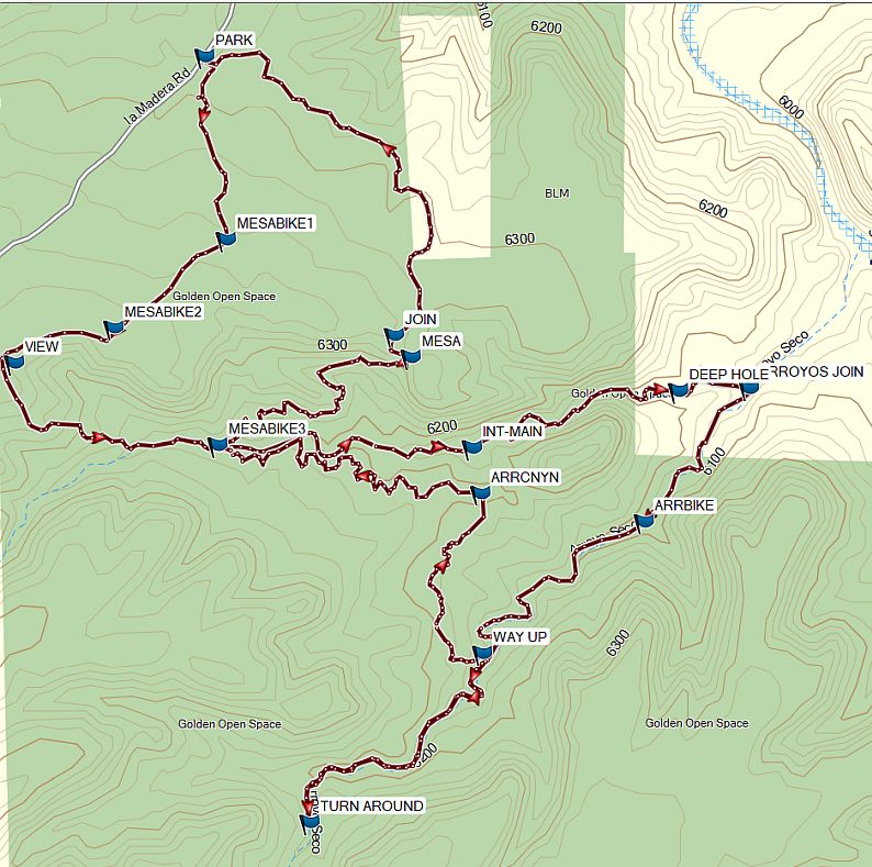
A variation that includes (1) all of the Mesa Bike Trail, (2) all of the main arroyo, and (3) all of the side Arroyo Seco. Colorful rocks and great views.
CautionsHiking off-trail in the arroyos with some walking on rocks. Bring your hiking poles.
Trailhead DirectionsFrom Albuquerque, take I-40 to North 14. In Cedar Crest just after the school on the left, turn left onto LA MADERA Road (the road to East Mountain High School). Stay on the windy but paved road until it turns to dirt at a cattleguard in about 7.5 miles. It is about 2 miles from this point to PARK (0.0 mi). Even though the road has curves, most of it is paved.
Actual HikeAfter going into the Golden Open Space, take a right to follow the Los Duendes Trail to MESABIKE1 (0.3 mi) and then MESABIKE2 (0.6 mi). Hikers have created a foot trail starting about here. Leave the Mesa Trail to your right, and continue to VIEW (0.8 mi). From there, go to your left downhill to get into the first arroyo. You’ll intersect another bike trail at MESABIKE3 (1.3 mi). Keep going all the way down this arroyo to its intersection with Arroyo Seco at ARROYOS JOIN (2.3 mi), admiring the colorful cliffs. Head up this arroyo, passing ARRBIKE (2.6 mi) (a bike trail that returns to your right), and WAY UP (3.1 mi) to the TURN AROUND (3.2 mi) point. Return to WAY UP (4.0 mi), make your way up a series of white limestone ledges, and go off-trail to ARRCNYN (4.5 mi) where you may join the bike trail or continue back to the main arroyo at INT-MAIN (4.6). In either case, make a left turn and continue until you return to MESABIKE3 (5.2 mi). Follow the trail up to your right until you reach the MESA (5.8), then JOIN (5.85 mi) the Los Duendes Trail to return to PARK.
CommentsElevated to C based on the parts that involve walking on rocks.
WaypointsAccess
LA MADERA TURN LEFT: N35 10.421, W106 20.225
Hike
PARK: N35 16.289, W106 19.695
MESABIKE1 N35 16.030, W106 19.659
MESABIKE2 N35 15.905, W106 19.850
VIEW: N35 15.855, W106 20.021
CAIRN: N35 15.763, W106 19.965
MESABIKE3: N35 15.740, W106 19.673
ARROYOS JOIN: 15.820, W106 18.764
ARRBIKE: N35 15.630, W106 18.944
UPDNROCK N35 15.470, W106 19.213
TURN AROUND: N35 15.206, W106 19.516
ARRCNYN: N35 15.671, W106 19.224
INT-MAIN: N35 15.735, W106 19.238
MESA: N35 15.863 W106 19.343
JOIN: N35 15.895, W106 19.371
Hike GPS File Name: GoldenBkArrWayTrack_MW
Hike GPS File: Click link to download hike waytrack file
Text Author: Marilyn Warrant
Map Author: Marilyn Warrant
Waypoints Author: Marilyn Warrant
Track Author: Marilyn Warrant
Maintainer: Marilyn Warrant
Editor: Dawn McIntyre