Ponderosa Trail At Juan Tomas Hike
In Cedro Peak Region
Map File Source: DeLorme
 Hike Key: H10319
Last Updated: 12/15/2020 12:00am
Last Updated By: Marilyn Warrant
Hike Class: B (Moderate)
Hike Distance: 4 mi
Minimum Elevation: 7290 ft
Elevation Change: 258 ft
Total Uphill: 265 ft
Total Downhill: 265 ft
Avg. Grade: 3 %
Route Type: CCW Loop
On Trail: Yes
Paved or Gravel Roads: Yes
GPS Advised: No
Drive Distance Round Trip: 56 mi
Drive Time One-Way: 0:45
Hiking Seasons: Spring, Summer, and Fall
New Mexico Game Unit: 14
Hike Status: Published
Highlights
Grass and wildflower meadows; ponderosa, juniper, pinon forest
CautionsNone.
Trailhead DirectionsFrom Albuquerque, take I-40 East to Tijeras Exit 175. Go South on SR 337 for about 9 miles to Oak Flats Road. Turn Left (East) and follow paved road for 3.5 miles until Anaya Road comes in from the right (South). This is where you will park as there is an Open Space Sign on the left (North) side of the road and this is the Trail Head.
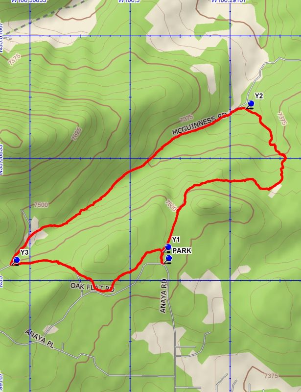
Actual HikeThis is a loop trail. At PARK, use the ‘walk-through’ opening in the fence, and continue North about 150 yards, you will encounter Y1. This marks the beginning and the end of the loop. Stay to the right. The trail meanders East through meadows, Juniper and Pinion forest. It loops around to the NE,N, then NW. At mile 1.5, you reach Y2 and make a strong left turn up a small hill. You will then be on a two track that appears to be an old road bed. Stay on this for approximately 1.5 miles until you approach Y3. Make a very sharp Left turn. After proceeding through meadow like terrain, this trail becomes narrow and winds through thick forest. At times you might be able to see Oak Flats Road on your right, but continue and you will soon be out of the woods at Y1. Turn right and head to PARK.
WaypointsPARK: N 35 00.071, W 106 17.836
Y1: N 35 00.117, W 106 17.838
Y2: N 35 00.704, W 106 17.424
Y3: N 35 00.065, W 106 18.597
Hike GPS File Name: PonderosaTrailAtJuanTomasWayTrack_CMCM.gpx
Hike GPS File: Click link to download hike waytrack file
Text Author: Cindy McConnell
Map Author: Cindy McConnell
Waypoints Author: Cindy McConnell
Track Author: Cindy McConnell
Maintainer: Cindy McConnell
Editor: Marilyn Warrant