Winsor Creek to Stewart Lake Hike
In Pecos Region
Map File Source: NG Topo
 Hike Key: H10005
Last Updated: 12/15/2020 12:00am
Last Updated By: Marilyn Warrant
Hike Class: D (Difficult)
Hike Distance: 8.1 mi
Minimum Elevation: 8464 ft
Elevation Change: 1777 ft
Total Uphill: 1856 ft
Total Downhill: 1856 ft
Avg. Grade: 12 %
Route Type: InOut
On Trail: No
Paved or Gravel Roads: Yes
GPS Advised: No
Hiker Limit (NF/BLM/NP): 15 (Pecos Wilderness)
Drive Distance Round Trip: 200 mi
Drive Time One-Way: 2:00
Hiking Seasons: Summer and Fall
New Mexico Game Unit: 45
Hike Status: Published
Highlights
A strenuous hike in the woods with lush wildflowers along the trail, as well as at the lake.
CautionsSteep (12% grade) uphill and downhill. Hiking poles recommended. Not recommended for hikers with respiratory disorders. Lots of down timber.
Trailhead Directions
Go north on I-25 to Exit 299 Glorieta. Cross over the highway, turn right onto NM 50, and travel 6 mi to the town of Pecos and a junction with NM 63. Turn left, and proceed 20.2 mi to Cowles. Make a left turn over the Pecos River onto Forest Road 121. Continue on this road for a little over a mile to the end of the road and Winsor Creek Campground.
Actual Hike
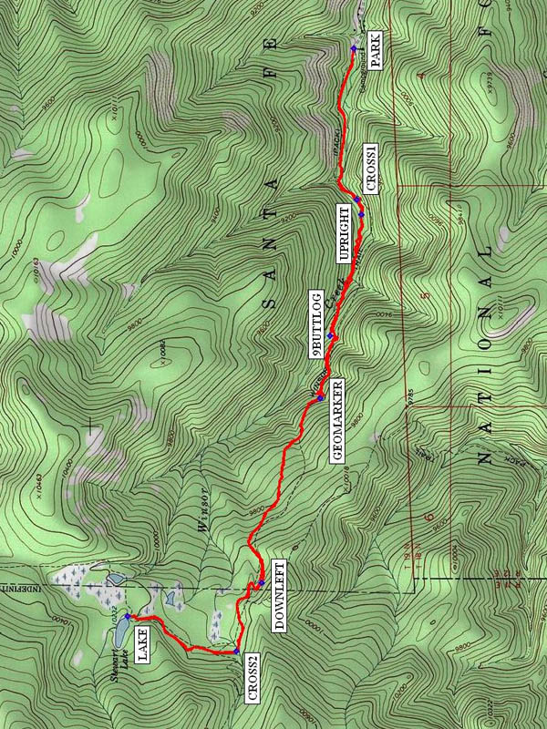
Start hiking at Trail 254 (Winsor Trail) which parallels the creek going upstream. Just after you cross the creek at CROSS1 (0.8 mi), the trail splits. Take the trail (it may be marked Trail 261) that goes straight following the creek upstream (UPRIGHT (0.9 mi)). Note that the Winsor Creek trail is no longer maintained. (Do not take the trail that makes a sharp turn back to the left and begins to climb up away from the creek.) Trail 261 follows the creek for about 0.7 mi. and then begins to climb up to the left away from the creek. There’s a good place to take a break at 9BUTTLOG (1.6 mi) (there were nine of us, and we all fit). You’ll pass a GEOMARKER (2.1 mi) with the elevation listed. In about 1.2 mi., you will meet up with the Winsor Trail again. There may not be a marker here, so after marking the trail you came from with a cairn, go straight ahead. (Not to the left.) When you return you will go DOWNLEFT (3.2 mi) at this location. Soon you will come to an intersection. There is a good sign here. Cross the stream at CROSS2 (3.6 mi), and take the trail to Stewart LAKE (4.2 mi), which is just one-half mile more. After lunch at the lake, turn around and go back the same way, looking for the trail you marked going up.
Comments
THIS HIKE REQUIRES A LATE RETURN. The trail to this lovely mountain lake is partly along a stream and on a trail that goes through lush conifers and aspens with the potential for many wildflowers along the way. We saw a yellow ladyslipper and an elephanthead. This is a pretty ambitious hike. At any point, the group can decide to turn around, or a few can soldier on behind the stronger hikers and arrive late at the lake.
WaypointsPARK: N 35 48.965, W 105 40.715
CROSS1: N 35 48.953, W 105 41.445
UPRIGHT: N 35 48.934, W 105 41.516
9BUTTLOG: N 35 49.059, W 105 42.102
GEOMARKER: N 35 49.096, W 105 42.403
DOWNLEFT: N 35 49.327, W 105 43.298
CROSS2: N 35 49.428, W 105 43.628
LAKE: N 35 49.856, W 105 43.457
Hike GPS File Name: WinsorCreektoStewartLakeWayTrack_MWMW.gpx
Hike GPS File: Click link to download hike waytrack file
Text Author: Frances Arnold
Map Author: Marilyn Warrant
Waypoints Author: Marilyn Warrant
Track Author: Marilyn Warrant
Maintainer: Marilyn Warrant
Editor: Howard Carr