Rattlesnake Ridge Ruins Hike
In Rio Chama Region
Map File Source: NG Topo
 Hike Key: H10567
Last Updated: 02/25/2025 9:03pm
Last Updated By: Marilyn Fixer
Hike Class: A (Easy)
Hike Distance: 1.2 mi
Minimum Elevation: 7347 ft
Elevation Change: 63 ft
Total Uphill: 160 ft
Total Downhill: 160 ft
Avg. Grade: 7 %
Route Type: InOut
On Trail: Yes
Paved or Gravel Roads: Yes
GPS Advised: No
Drive Distance Round Trip: 273 mi
Drive Time One-Way: 3:00
Hiking Seasons: Spring, Summer, and Fall
New Mexico Game Unit: 5B
Hike Status: Published
Highlights
This is easy hike on a gravel trail to one of the Gallina Indian ruins. Little is known about the Gallina Indians who don’t seem to have any living relatives and met a violent death.
CautionsNone.
Trailhead Directions
I-25 north to Bernalillo, exit 242, west on US 550 past Cuba, make a right turn onto NM 96, go north and at curve on NM 96 go straight onto NM 112, continue north approximately 18 mile and then turn left onto FR 390 which is a 1 1/2 lane road so watch for logging trucks. Go approximtely 1/8 mile and turn right onto rutted dirt road to parking area. Also you can park in a safer area along the side of the road at NM 112 and FR 390 and hike the 1/2 mile to the trailhead.
Actual Hike
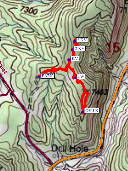
From PARK (0.0) go east through RR ties and travel on the gravel trail to the tee. At the tee turn right and go south to TW (0.25 mi.) to see remnants of a tower. Next continue south to the end at OV LK (0.5 mi) for an overlook and more ruins. Next turn around and go NW back to the tee and continue north on the gravel trail to KV (0.75 mi.) for a kiva, continue up trail to 2 KV (0.8 mi) and onto 3 KV (0.85 mi) for a third kiva. Next turn around and hike down the trail to the tee, make a right turn here and hike back down the gravel trail to the parking area (1.2 mi.).
Comments
See the massive number of deer and elk tracks all along the trail. These ruins are the largest documented village site in the Gallina area. The village had single unit dwellings, multiroom structures, towers, pit houses, storage rooms and a reservoir system. For more information about Rattlesnake Ridge Ruins, see Rattlesnake Ridge Ruins and The New Mexico Archaeology rchaeology Newsletter – Gallina Field Trip Report.
WaypointsPARK: N36 28.982, W106 49.601
TW: N36 28.980, W106 49.447
OV LK: N36 28.862, W106 49.414
KV: N36 29.042, W106 49.473
2 KV: N36 29.076, W106 49.458
3 KV: N36 29.106, W106 49.448
Hike GPS File Name: RattlesnakeRidgeRuinsWayTrack1_FE.gpx
Hike GPS File: Click link to download hike waytrack file
Text Author: Frank Ernst
Map Author: Marilyn Warrant
Waypoints Author: Vivian Heyward
Track Author: Frank Ernst
Maintainer: Not Assigned
Editor: Howard Carr