Poshuouinge Ruins Hike
In Ghost Ranch Region
Map File Source: Garmin BaseCamp
 Hike Key: H10644
Last Updated: 03/19/2021 12:00am
Last Updated By: Marilyn Fixer
Hike Class: A (Easy)
Hike Distance: 1 mi
Minimum Elevation: 5961 ft
Elevation Change: 219 ft
Total Uphill: 219 ft
Total Downhill: 219 ft
Avg. Grade: 8 %
Route Type: InOut
On Trail: Yes
Paved or Gravel Roads: Yes
GPS Advised: No
Drive Distance Round Trip: 230 mi
Drive Time One-Way: 1:45
Hiking Seasons: Spring, Summer, and Fall
New Mexico Game Unit: 5B
Hike Status: Published
Highlights
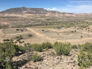
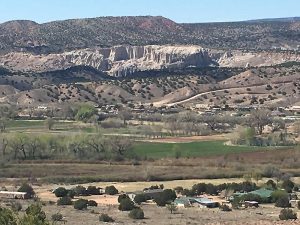
Ancient unexcavated ruins with views of the Chama River Valley and one of the largest Rio Grande Pueblo ruins of Tewa ancestors. Trail is short and steep.
CautionsStrenuous climb in some places. Poles are encouraged for those who need them.
Trailhead Directions
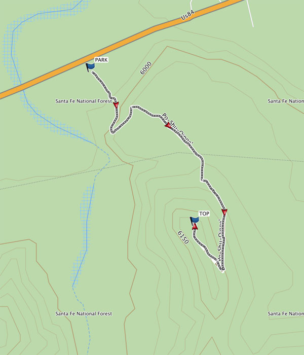
Take I-25 to 599 Santa Fe bypass. At the end, take exit 84-285 to Espanola. Take either route in Espanola to get to US 84/285. At mile marker 192, the divided highway ends and you are now on US 84. Poshuouinge Ruins are on the west side of the highway between mile marker 208 and 210 at the guard rail and right by the Family Dollar. A National Forest Service sign on the west side marks the entrance. There is a small parking area next to the trailhead.
It’s also 2.5 miles south of Abiquiu on U.S. Highway 84.
Actual Hike
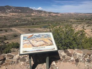
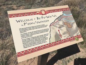
From PARK, find the well defined trail that skirts along the edge to the top of the hill for a great view of the ancestral ruins of the Tewa village that was partially excavated in the early 1900’s. Stay on the trail as you make your way up and read the interpretive signs for the history of the area. There are two vistas, one with a ramada covered bench. Stop and take in the views of the valley and the outline of the pueblo as you continue to the TOP (0.5 mi) where the best views are. From here, you can see the whole village outline. Look at the diorama of how the village appeared when it was inhabited.
Poshuouinge is Tewa and means “Village Above the Muddy River”. It was inhabited around 1450 AD and the village is part one story, part two story with a kiva on one side and included a plaza. Because it has only been partially excavated, you will simply see an outline of the village. While at the top, look for a shallow, rock ringed circular depression that showed evidence of a hearth and stone tool fragments.
Return to PARK (1.0 mi) the way you came.
Comments
An additional hike to Continental Divide Trail near Echo Canyon, Section 27, is possible. Continue on Hwy 84 past Abiquiu Lake, Ghost Ranch and former wildlife preserve. There are bathroom facilities at Echo Canyon turnoff if needed. Continue past mile marker 232 and Blue Angel Canyon. At the end of the guard rail, on the west side, is a sanctuario, La Virgen Maria. The Continental Divide Trail Section 27 begins before the bridge, and parking is wherever it is available, especially if the road is muddy.
WaypointsPARK: N36 12.814, W106 16.659
TOP: N36 12.634, W106 16.514
Hike GPS File Name: PoShuOuingeRuins_DMDM.gpx
Hike GPS File: Click link to download hike waytrack file
Text Author: Dawn McIntyre
Map Author: Dawn McIntyre
Waypoints Author: Dawn McIntyre
Track Author: Dawn McIntyre
Maintainer: Cathy Intemann
Editor: Marilyn Warrant