Winsor Trail to Spirit Lake from Ski Area Hike
In Sangre De Cristos Region
Map File Source: NG Topo
 Hike Key: H10664
Last Updated: 12/15/2020 12:00am
Last Updated By: Marilyn Warrant
Hike Class: E (Most difficult)
Hike Distance: 11.9 mi
Minimum Elevation: 10350 ft
Elevation Change: 735 ft
Total Uphill: 2360 ft
Total Downhill: 2360 ft
Avg. Grade: 10 %
Route Type: InOut
On Trail: Yes
Paved or Gravel Roads: Yes
GPS Advised: No
Hiker Limit (NF/BLM/NP): 15 (Pecos Wilderness)
Drive Distance Round Trip: 160 mi
Drive Time One-Way: 1:45
Hiking Seasons: Summer and Fall
New Mexico Game Unit: 44
Hike Status: Published
Highlights
A strenuous hike through lush forest to a mountain lake. Wildflowers; views of surrounding mountain peaks.
CautionsA rocky trail with steep sections and little soft footing. Trekking poles recommended. High altitude; not recommended for hikers with respiratory disorders.
Trailhead Directions
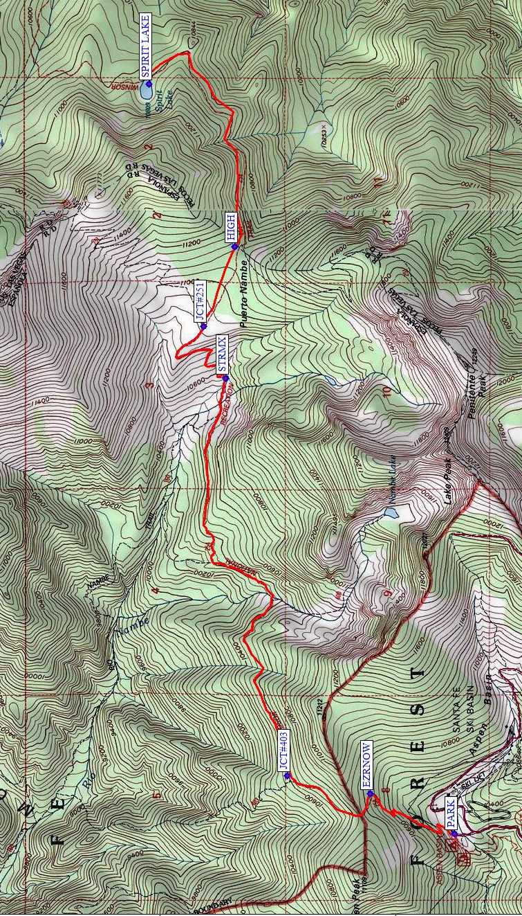
From Albuquerque take I-25 north to Santa Fe and take exit #284 north on Old Pecos Trail, which after about 3 miles becomes Old Santa Fe Trail, then turn right (east) on Paseo de Peralta. This street soon curves north and crosses the Santa Fe River where you turn right (east) on East Alameda St. Continue east about .75 mile and turn left (northeast) onto Gonzales Rd. Drive northeast just over 1 mile to Hyde Park Rd (NM 475) and turn right and drive about 14 miles to the Ski Area parking. PARK (0.0 mi) is on the northwest side near the privy and the trail information display board.
Actual Hike
The hike follows Winsor Trail (#254), a wide, rocky, worn, popular trail, and begins at 10,250′ elevation. There is an initial 600′ ascent for 0.4 mi. from the ski area using long, steep switchbacks through the forest to EZRNOW (0.7 mi) then to the Pecos Wilderness boundary. A very gradual descent follows for about 2 miles (total elevation loss about 550′). You’ll pass the junctions with Lower Nambe Trail #403 (JCT#403 (1.3 mi)) to the left. The main Winsor Trail continues to a log bridge crossing the west fork of the Rio Nambe at about 2.5 mi. Our Trail 254 continues climbing gradually, and eventually the forest opens up to small meadow areas of wildflowers (penstemon, harebell, black-eyed susan, coneflower, geraniums, and huge white and periwinkle columbines), and fist-sized red mushrooms. Our trail crosses several branches of the east fork of the Rio Nambe at STRMX (3.6 mi). After crossing, climb the gentle switchbacks and note Trail #160 coming in from the left (west), stay on Trail #254 and soon reach a grassy meadow and JCT#251 (4.3 mi). This is a lower meadow of Puerto Nambe. Continue on the Winsor Trail to the HIGH (4.6 mi) point of the hike at 11095′. Then hike downhill to SPIRIT LAKE (5.9 mi). Return the way you came.
Comments
This hike is a continuation of the Winsor Trail to Puerto Nambe hike; 3 mi and 600′ up/down additional to go to Spirit Lake.
WaypointsPARK: N35 47.754, W105 48.279
EZRNOW: N35 48.112, W105 48.070
JCT#403: N35 48.464, W105 47.978
STRMX: N35 48.724, W105 45.911
JCT#251: N35 48.817, W105 45.641
HIGH: N35 48.687, W105 45.227
SPIRIT LAKE: N35 49.049, W105 44.383
Hike GPS File Name: WinsorTrailToSpiritLakeFromSkiArea1_MW.gpx
Hike GPS File: Click link to download hike waytrack file
Text Author: Ken Smith
Map Author: Marilyn Warrant
Waypoints Author: Ken Smith
Track Author: Marilyn Warrant
Maintainer: Not Assigned
Editor: Dawn McIntyre