Winsor Ridge to Stewart Lake Hike
In Pecos Region
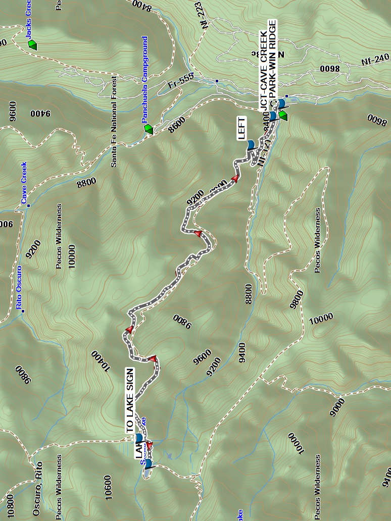
Map File Source: Garmin BaseCamp
 Hike Key: H10696
Last Updated: 09/13/2023 11:27am
Last Updated By: Dawn McIntyre
Hike Class: E (Most difficult)
Hike Distance: 11.8 mi
Minimum Elevation: 8200 ft
Elevation Change: 2040 ft
Total Uphill: 2220 ft
Total Downhill: 2220 ft
Avg. Grade: 9 %
Route Type: InOut
On Trail: Yes
Paved or Gravel Roads: Yes
GPS Advised: No
Hiker Limit (NF/BLM/NP): 15 (Pecos Wilderness)
Drive Distance Round Trip: 200 mi
Drive Time One-Way: 2:00
Hiking Seasons: Summer and Fall
New Mexico Game Unit: 45
Hike Status: Published
Highlights
A strenuous hike in the woods with lush wildflowers along the trail, as well as at the lake. Conifers & aspens.
CautionsHiking poles recommended. High altitude; not recommended for hikers with respiratory disorders.
Trailhead Directions
From Albuquerque, go north on I-25 to Exit 299 Glorieta. Cross over the highway, turn right onto NM 50, and travel 6 mi to the town of Pecos and a junction with NM 63. Turn left, and proceed 20.2 mi to Cowles. PARK in the lot at the intersection with FR-121.
Actual Hike
From PARK-WIN RIDGE, start hiking on the Winsor Ridge trail which goes steadily uphill. Pass the JCT-CAVE CREEK (0.2 mi). At the next trail junction, go LEFT (1.0 mi). Continue hiking uphill through the forest. Depending on your start time and how fast your group hikes uphill, you may want to eat lunch before you come to the TO LAKE SIGN (5.6 mi) and the LAKE (5.9 mi). Otherwise, eat lunch at the lake. Return the way you came.
Comments
THIS HIKE WILL RETURN LATE. This is a long hike, so allow plenty of time.
The elevation data were obtained from a track recorded on a Garmin 64st; average grade from National Geographic Topo.
WaypointsDQ: N35 34.509, W105 41.763
PARK: N35 48.712, W105 39.601
JCT-CAVE CREEK: N35 48.787, W105 39.734
LEFT: N35 48.976, W105 40.043
TO LAKE SIGN: N35 49.936, W105 43.183
LAKE: N35 49.856, W105 43.457
Hike GPS File Name: WinsorRidgeToStewartLake500_MW.gpx
Hike GPS File: Click link to download hike waytrack file
Text Author: Nan Burke
Map Author: Marilyn Warrant
Waypoints Author: Marilyn Warrant
Track Author: Debbie Manoogian
Maintainer: Marilyn Warrant
Editor: Dawn McIntyre