Valles Caldera National Preserve – South Mountain Hike
In Jemez Mountains Region
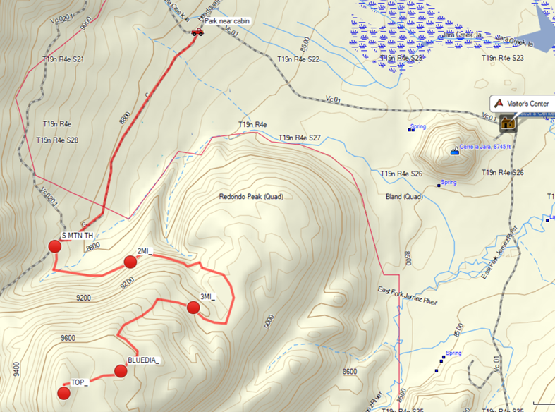
Map File Source: Garmin BaseCamp
 Hike Key: H10486
Last Updated: 06/30/2021 12:00am
Last Updated By: Marilyn Fixer
Hike Class: C (Challenging)
Hike Distance: 8.4 mi
Minimum Elevation: 8740 ft
Elevation Change: 1020 ft
Total Uphill: 1212 ft
Total Downhill: 1212 ft
Avg. Grade: 8 %
Route Type: InOut
On Trail: Yes
Paved or Gravel Roads: Yes
GPS Advised: Yes
Hiker Limit (NF/BLM/NP): 15 (National Preserve)
Drive Distance Round Trip: 172 mi
Drive Time One-Way: 2:00
Hiking Seasons: Spring, Summer, and Fall
New Mexico Game Unit: 6B
Hike Status: Waiting Editor
Access Description: Valles Caldera North Access
Attractions: Forest
Highlights
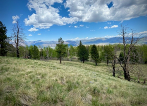
Super volcano! Views, huge meadows, possibility for viewing wildlife.
CautionsVehicles are not allowed up to the trailhead. The first and last 1 1/2 miles are mostly unshaded along a two-track.
Trailhead Directions
Take I-25 North and exit on to Hwy 550. In San Ysidro, take Hwy 4 to Jemez Pueblo and Jemez Springs. Follow Hwy 4 at fork at La Cueva (stay right). The Valles Caldera Preserve is about 22 miles from Jemez Springs. Look for the Main Gate at Mile Marker 39.2.
At the Visitor’s Center sign releases and pick up a tag for the van. Currently the VCNP does not require a fee but that may change in the future. It is wise to check the VCNP website prior to the trip.
From the Visitor’s Center drive north nearly two miles to PARK NEAR CABIN (0.0 mi).
Actual Hike
Hike along a two-track to S MTN TH (1.5 mi) and proceed south onto the well-marked trail up the mountain. The 2MI (2.0 mi) and 3MI (3.0 mi) waypoints represent the most strenuous climbing of the hike..
The lovely, woodsy trail continues to ascend up the mountain until it reaches a large meadow and the last trail mark at BLUEDIA (3.8 mi), where the trail disappears. The large meadow seems like the obvious way up to the summit. However, the meadow is full of deep bogs and the easier way up is to cross the open space heading to the trees on the opposite side (southward). Then follow the trees for the final quarter of a mile and up the last grassy knoll to the TOP (4.2 mi). The summit is actually an unadorned meadow surrounded by woods without any 360 deg. views. The shady hike down is quite enjoyable.
Comments
No one would describe the South Mountain hike “spectacular”, but it may meet the description in the Valles Caldera website, “… a chance to get out and really experience a sense of solitude that we hope will leave you refreshed and relaxed.”
The group is limited to 15 hikers unless you get a Special Use Permit.
Check the Valles Caldera website for current information.
WaypointsPARK: N35 51.802, W106 31.144
SOUTH MTN TH: N35 50.869, W106 31.919
2MI: N35 50.803, W106 31.510
3MI: N35 50.606, W106 31.169
BLUEDIA: N35 50.328, W106 31.561
TOP: N35 50.232, W106 31.868
Hike GPS File Name: 2021_06_04_SouthMtn_BG
Hike GPS File: Click link to download hike waytrack file
Text Author: Bill Gloyd
Map Author: Bill Gloyd
Waypoints Author: Bill Gloyd
Track Author: Bill Gloyd
Maintainer: Bill Gloyd
Editor: Marilyn Warrant