Valle de Oro Hike
In Albuquerque Region
Map File Source: NG Topo
 Hike Key: H10584
Last Updated: 03/19/2021 12:00am
Last Updated By: Marilyn Fixer
Hike Class: B (Moderate)
Hike Distance: 7 mi
Minimum Elevation: 19 ft
Elevation Change: 19 ft
Total Uphill: 19 ft
Total Downhill: 19 ft
Avg. Grade: %
Route Type: Messy
On Trail: Yes
Paved or Gravel Roads: Yes
GPS Advised: Yes
Drive Distance Round Trip: 25 mi
Drive Time One-Way: 0:30
Hiking Seasons: Spring, Summer, Fall, and Winter
New Mexico Game Unit: 9
Hike Status: Published
Highlights
In the winter see lots of migrating cranes and geese as well as some hawks, eagles and domestic animals nearby. A nice hike along the Bosque.
CautionsNone.
Trailhead Directions
I-25 south to Rio Bravo exit. Drive west to 2nd St., make a left turn and go south to the end of the paved road. (Notice all the birds in the fields you go past.) Next turn right and go west on the dirt road and then left on the east side of the ditch. Follow this ditch road to the end and park.
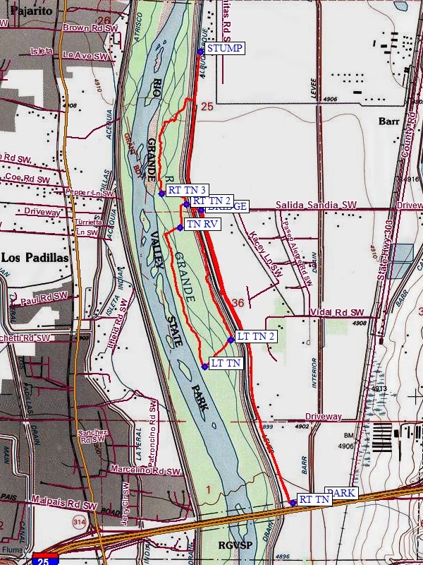
Actual Hike
From PARK (0.0 mi), go west and turn right at RT TN (0.1 mi) and proceed north along the ditch to BRIDGE (1.65 mi). Go west over ditch bridge and follow the trail west and then south to TN RV (1.85 mi). Here proceed west to the river and then south to LT TN (2.6 mi). Next proceed east to LT TN 2 (2.8 mi), then head north and then west to RT TN 2 (3.5 mi), turn right on this faint trail and head towards the river. Follow the trail to RT TN 3 (3.7 mi) and then head NE to the ditch bank to the east. Head north on the ditch bank to STUMP (4.55 mi) and notice the embedded cable in the stump. Finally go south to the bridge and follow the east side of the ditch south and back to PARK.
Comments
In 2014 the Valle de Oro was dedicated as the only urban wildlife refuge. See the Valle de Oro website. This hike borders the west side of the refuge and goes into the Bosque. Several coyotes have been sighted in the heavy brush areas south of this hike.
WaypointsPARK: N34 57.090, W106 40.519
RT TN: N34 57.065, W106 40.655
BRIDGE: N34 58.282, W106 41.119
TN RV: N34 58.209, W106 41.227
LT TN: N34 57.629, W106 41.101
LT TN 2: N34 57.743, W106 40.967
RT TN 2: N34 58.304, W106 41.193
RT TN 3: N34 58.348, W106 41.317
STUMP: N34 58.938, W106 41.123
Hike GPS File Name: ValleDeOroWayTrack1_FE.gpx
Hike GPS File: Click link to download hike waytrack file
Text Author: Frank Ernst
Map Author: Marilyn Warrant
Waypoints Author: Frank Ernst
Track Author: Frank Ernst
Maintainer: Frank Ernst
Editor: Howard Carr