San Jose Badlands Hike
In Cuba Region
Map File Source: DeLorme
 Hike Key: H10522
Last Updated: 12/05/2023 10:19pm
Last Updated By: Marilyn Fixer
Hike Class: B (Moderate)
Hike Distance: 5.5 mi
Minimum Elevation: 7210 ft
Elevation Change: 205 ft
Total Uphill: 585 ft
Total Downhill: 585 ft
Avg. Grade: 5 %
Route Type: Lollypop
On Trail: No
Paved or Gravel Roads: No
GPS Advised: Yes
Drive Distance Round Trip: 210 mi
Drive Time One-Way: 2:00
Hiking Seasons: Spring and Fall
New Mexico Game Unit: 5A
Hike Status: Published
Access Description: San Pedro Parks Access
Highlights
This hike is loaded with badlands and sandstone formations for its entire route.
CautionsThe hike is off trail. Poles may be useful.
Trailhead Directions
From Albuquerque take I-25 north to Bernalillo. Go west on US 550 through San Ysidro, thru Cuba (reset the odometer here), Continue north on US 550 for 3.5 miles to SSR 96 on the right. Take SR 96 for 13 miles to a bend in the road to the right. Go STRAIGHT (this is SR 112) for one mile to CR391 on the left. Take CR 391 for 2.8 miles to a well pad road on the right and go 0.1 miles to PARK.
Actual Hike
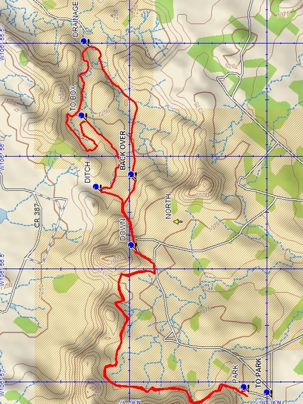
From PARK (0.0 mi) go over the low ridge to the north and follow the track along the base of the towering formations to your left. Follow the track which makes a right turn of 90 degrees, taking you to a well traveled well road. Go left on this road to DOWN (1.5 mi). The road goes down into a whole new area, which will be spread out before you. At the DITCH (1.8 mi) to the right go down and follow the wash to TO BOX (2.2 mi). Curve around to the left and enter a huge dead end canyon. Follow around the edge and back out the other side. Continue to the DRAINAGE (3.0 mi). Turn right up this wash which will take you back in the direction you entered and go BACK OVER (3.7 mi) the right side of the canyon to the road you came down. From this point retrace your route to PARK.
Comments
The use of a GPS for leading this hike is recommended as there are no trails at this site.
The hike can be shortened on the way back by staying on the well road until past the low rise at the start of the hike and going right back to PARK.
WaypointsCR391: N 36 15.623, W 106 55.141
NORTH: N 36 16.840, W 106 56.291
STRAIGHT: N 36 14.242, W 106 55.658
TO PARK: N 36 16.483, W 106 57.071
PARK: N 36 16.568, W 106 57.049
DOWN: N 36 16.977, W 106 56.417
DITCH: N 36 17.104, W 106 56.161
TO BOX: N 36 17.158, W 106 55.843
DRAINAGE: N 36 17.150, W 106 55.515
BACK OVER: N 36 16.977, W 106 56.106
Hike GPS File Name: SanJoseBadlandsWayTrack_DBDB.gpx
Hike GPS File: Click link to download hike waytrack file
Text Author: Dick Brown
Map Author: Dick Brown
Waypoints Author: Dick Brown
Track Author: Dick Brown
Maintainer: Carl Gervais
Editor: Randy Simons