Palomas Trail Hike
In San Pedro Parks Region
Map File Source: NG Topo
 Hike Key: H10552
Last Updated: 12/05/2023 9:43pm
Last Updated By: Marilyn Fixer
Hike Class: C (Challenging)
Hike Distance: 7.7 mi
Minimum Elevation: 9250 ft
Elevation Change: 926 ft
Total Uphill: 1240 ft
Total Downhill: 1240 ft
Avg. Grade: 7 %
Route Type: InOut
On Trail: Yes
Paved or Gravel Roads: Yes
GPS Advised: Yes
Hiker Limit (NF/BLM/NP): 15 (San Pedro Parks Wilderness)
Drive Distance Round Trip: 205 mi
Drive Time One-Way: 2:15
Hiking Seasons:
New Mexico Game Unit: 6A
Hike Status: Published
Access Description: San Pedro Parks Access
Highlights
San Pedro Parks wilderness trail through beautiful high meadows with small streams, huge evergreens, wonderful wildflowers and pretty rocks.
CautionsHiking sticks helpful for up and downhill sections.
Trailhead Directions
I-25 north to Bernalillo exit 242, then west on US 550 to Cuba. Turn right (east) on SR 126 and travel 10 miles to FR 70. Turn left and drive 9-10 miles to PARK for Palomas Trail on the left (trailhead is 7 miles past the San Gregorio Reservoir trailhead parking).
Actual Hike
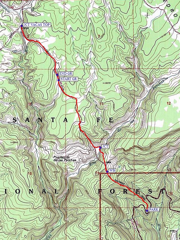
Palomas Trail #50 climbs through the forest steeply for the first ¼ mile. The trail soon enters the Wilderness Boundary WB (0.9 mi) and reaches a high point. After a steep but short descent, the trail crosses a small stream and turns right. At a sign posted junction JCT (1.4 mi) bear left and follow the Palomas and Rio de Las Vacas Trail. Damian Trail soon enters from the left, but continue on Palomas/Vacas. The trail climbs steadily through forest and then opens to a series of meadows surrounded by tall evergreens, the ‘parks’ for which the area is named. One of these parks START GR (2.8 mi) is both grassy and marshy END GR (2.9 mi) and it may be hard to see where the trail goes. Use the two GR waypoints as a guide. The Palomas Trail ends at JCT VACAS TOP (3.9 mi). Have lunch there by the stream and then return by the same route.
Comments
Plan on a late return. This hike goes right into the heart of the San Pedro Parks. These beautiful high meadows are quite level areas with lots of little streams, huge evergreens, wonderful wildflowers and pretty rocks. Weather can be changeable, so come prepared for possible wind, rain, even a bit of hail. Traveling in this area prior to Memorial Day you will most likely encounter very wet conditions. 15 person limit in San Pedro Parks Wilderness.
WaypointsPARK: N 36 02.533, W 106 47.545
WB: N 36 03.025, W 106 48.162
JCT: N 36 03.332, W 106 48.269
START GR: N 36 04.184, W 106 48.921
END GR: N 36 04.251, W 106 48.939
JCT VACAS TOP: N 36 04.871, W 106 49.495
Hike GPS File Name: PalomasTrailWayTrackRev_SPSP.gpx
Hike GPS File: Click link to download hike waytrack file
Text Author: Judie Schwartz
Map Author: Dick Brown
Waypoints Author: Sue Pelletier
Track Author: Sue Pelletier
Maintainer: Randy Simons
Editor: Marilyn Warrant