Orilla Verde – Picuris – Klauer – Slide Loop Hike
In Taos Region
Map File Source: Garmin BaseCamp
 Hike Key: H10651
Last Updated: 12/15/2020 12:00am
Last Updated By: Marilyn Warrant
Hike Class: C (Challenging)
Hike Distance: 5.8 mi
Minimum Elevation: 6090 ft
Elevation Change: 700 ft
Total Uphill: 1140 ft
Total Downhill: 1140 ft
Avg. Grade: 8 %
Route Type: CCW Loop
On Trail: Yes
Paved or Gravel Roads: Yes
GPS Advised: Yes
Drive Distance Round Trip: 230 mi
Drive Time One-Way: 2:15
Hiking Seasons: Spring, Fall, and Winter
New Mexico Game Unit: 49
Hike Status: In Process
Highlights
Views of the Rio Grande, Rio Pueblo, and Taos Junction Bridge from river-level and from the mesa 700 feet above. Dramatic cliffs, wildlife sightings, and a powerful confluence of two rivers.
CautionsSteep grade of 17% for the first mile. Full sun exposure hiking along the mesa.
Trailhead Directions
From Albuquerque, take I-25 North to Exit 276. Follow NM-599 North for 13 miles. Use the left lane to merge onto US-285 N/US-84 W and travel 22 miles. Continue on NM-68 for 29 miles to the Rio Grande Gorge Visitor Center. From the visitor center, take NM-68 North just 410 feet, and make a left turn on NM-570. Follow scenic 570 for 6 miles to Picuris trailhead near the Taos Junction Bridge and PARK there.
Actual Hike
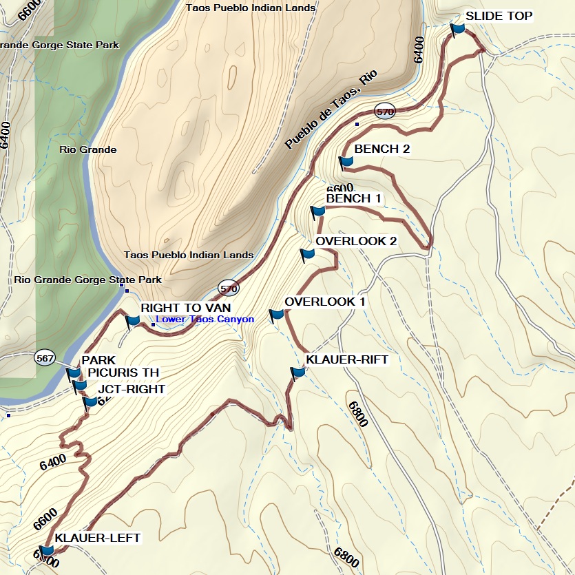
Follow Picuris Trail, an old stock route, to the top of the mesa. The trail is narrow, steep and rocky, but fairly easy to follow. Note the petroglyph on the prominent basalt rock to your right roughly 1/3 of your way up. Once at the top, you are on the Taos Valley Overlook, a system of single-track and two-track trails on 2,600 acres of sagebrush mesa. Views of the Taos Mountains will be to the northeast while the gorge will be to the west. At KLAUER-LEFT (0.8 mi) stay to the left, following Klauer Trail N/NE to its junction with Rift Valley Trail at KLAUER-RIFT (1.9 mi). Head N/NW on Rift Valley Trail to beautiful OVERLOOK 1 (2.1 mi) for lunch. Continue north along the edge of the escarpment to OVERLOOK 2 (2.3 mi). The trail winds around rifts in the mesa, connecting with Cascabel Trail. Enjoy the scenic overlooks into the Rio Pueblo gorge from this trail before you reach the parking lot at the top of The Slide Trail (Old 570) at SLIDE TOP (4.1 mi). Follow The Slide Trail along the Rio Pueblo down the mesa. To return to the van, hike along the road by the river or use the new connector trail, accessed on the left side of the road, back to Picuris trailhead.
Comments
You can hike in a clockwise direction by taking The Slide Trail up the mesa, crossing the mesa heading south, and taking Picuris Trail down.
The informative Rio Grande Gorge Visitor Center in Pilar is open 7 days a week. Sheltered picnic tables, clean restrooms, and access to Las Minas trailhead are available here. Call 575-751-4899 for summer and winter hours.
The Slide Trail is named for the 1993 rock slide that closed old SR-570. 57,000 tons of basalt rock fell from the side of an embankment onto the unpaved road. Built in 1915, the road provided access to the Rio Grande Railroad near the bridge.
WaypointsPARK: N36 20.139 W105 44.003
PICURIS TH: N36 20.108 W105 43.984
JCT-RIGHT: N36 20.066 W105 43.950
KLAUER-LEFT: N36 19.692 W105 44.086
KLAUER-RIFT: N36 20.141 W105 43.298
OVERLOOK 1: N36 20.286 W105 43.365
OVERLOOK 2: N36 20.440 W105 43.268
BENCH 1: N36 20.547 W105 43.235
BENCH 2: N36 20.671 W105 43.147
SLIDE TOP: N36 21.007 W105 42.797
RIGHT TO VAN: N36 20.271 W105 43.816
Hike GPS File Name: OrillaVerdeWayTrack_EKMW.gpx
Hike GPS File: Click link to download hike waytrack file
Text Author: Ellen Kahn
Map Author: Marilyn Warrant
Waypoints Author: Ellen Kahn
Track Author: Marilyn Warrant
Maintainer: Not Assigned
Editor: