Embudo to Copper Hike
In Sandia Mountain West Region
Map File Source: DeLorme
 Hike Key: H10262
Last Updated: 12/15/2020 12:00am
Last Updated By: Marilyn Warrant
Hike Class: B (Moderate)
Hike Distance: 4 mi
Minimum Elevation: 5969 ft
Elevation Change: 417 ft
Total Uphill: 480 ft
Total Downhill: 480 ft
Avg. Grade: 7 %
Route Type: CW Loop
On Trail: Yes
Paved or Gravel Roads: Yes
GPS Advised: No
Drive Distance Round Trip: 20 mi
Drive Time One-Way: 0:15
Hiking Seasons: Spring, Fall, and Winter
New Mexico Game Unit: 8
Hike Status: Published
Highlights
Easy hike but still a good workout. Enjoyable views of Albuquerque.
CautionsNone.
Trailhead Directions
Take Tramway to Indian School, go east on Indian School and park in the small parking lot on the right before the big parking lot over the hill.
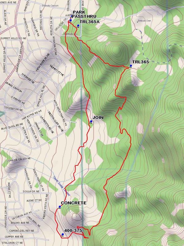
Actual Hike
Follow foothill trails #401 and #365 to make a loop.
Comments
Trail 365 goes all the way from I-40 to the tram terminal. Many views of nice residential areas.
WaypointsPARK: N35 05.925, W106 28.879
PASSTHRU: N35 05.901, W106 28.888
TRL365A: N35 05.874, W106 28.839
TRL365: N35 05.661, W106 28.491
400-375: N35 04.764, W106 28.939
CONCRETE: N35 04.911, W106 28.959
JOIN: N35 05.365, W106 28.753
Hike GPS File Name: EmbudotoCopperWayTrack_DBDB.gpx
Hike GPS File: Click link to download hike waytrack file
Text Author: Roger Holloway
Map Author: Dick Brown
Waypoints Author: Dick Brown
Track Author: Dick Brown
Maintainer: Not Assigned
Editor: Howard Carr