Dale Ball Trails – Sierra del Norte West Hike
In Santa Fe Region
Map File Source: Other
 Hike Key: H10683
Last Updated: 12/15/2020 12:00am
Last Updated By: Marilyn Warrant
Hike Class: B (Moderate)
Hike Distance: 3.5 mi
Minimum Elevation: 0 ft
Elevation Change: 150 ft
Total Uphill: 0 ft
Total Downhill: 0 ft
Avg. Grade: %
Route Type: Loop
On Trail: Yes
Paved or Gravel Roads: No
GPS Advised: No
Drive Distance Round Trip: 126 mi
Drive Time One-Way: 1:00
Hiking Seasons: Spring, Summer, Fall, and Winter
New Mexico Game Unit: 44
Hike Status: In Process
Highlights
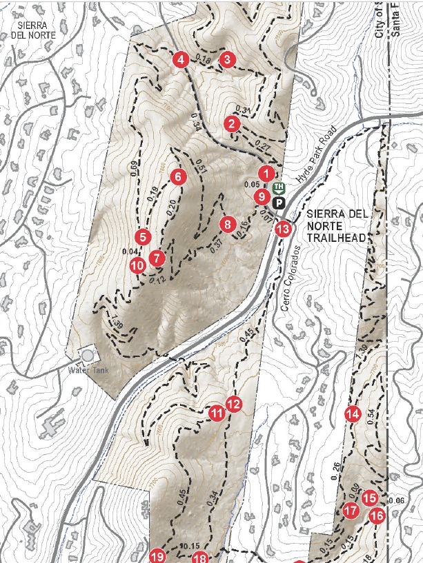
This is the northern section of the extensive Dale Ball Trails. We will explore sections on both sides of Hyde Park Road. The Dale Ball system is well-marked with maps at regular intervals which make this easy to follow without a GPS. The trails are well-traveled and hikers may encounter bikes.
CautionsNone.
Trailhead Directions
Get on I-25 N from San Mateo Blvd NE. 6 min (2.4 mi) Follow I-25 N to NM-466 N/Old Pecos Trail in Santa Fe County. Take exit 284 from I-25 N 43 min (53.2 mi)
Continue on Old Pecos Trail. Take Paseo De Peralta and Hyde Park Rd to Sierra Del Norte in Santa Fe. Turn into the parking lot.
Actual Hike
We will begin a gradual uphill following the trail markers in this order. We will proceed to 1,2,3,4,5,10,11,12 13 to parking lot. The hike crosses Sierra Del Norte road at marker 4 and Hyde Park Road between 10 and 11 and again at 13 to return to the parking lot.
Comments
You can view the hike on the internet by going to Santa Fe Foothill Trails. You can check out the route we will follow.
Map Filename: DaleBallTrails-SierradelNorteWest Map.jpgText Author: Cathy Intemann
Map Author:
Waypoints Author:
Track Author:
Maintainer: Cathy Intemann
Editor: Marilyn Warrant