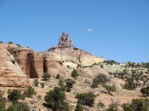
Church Rock Hike
In Northwest New Mexico Region
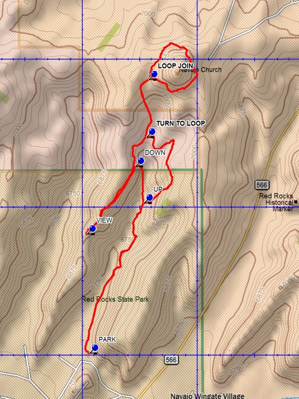
Map File Source: DeLorme
 Hike Key: H10407
Last Updated: 03/08/2021 12:00am
Last Updated By: Marilyn Fixer
Hike Class: B (Moderate)
Hike Distance: 4.1 mi
Minimum Elevation: 6700 ft
Elevation Change: 460 ft
Total Uphill: 595 ft
Total Downhill: 595 ft
Avg. Grade: 8 %
Route Type: Messy
On Trail: Yes
Paved or Gravel Roads: Yes
GPS Advised: Yes
Drive Distance Round Trip: 280 mi
Drive Time One-Way: 2:15
Hiking Seasons: Spring and Fall
New Mexico Game Unit: 10
Hike Status: Published
Highlights
Circle the Church Rock formation and walk the tops of tent rock formations.
CautionsThe hike is off trail. Poles may be useful.
Trailhead Directions
From Albuquerque take I-40 to the Fort Wingate exit (Exit 33). Take route 66 west for 4 miles to SR-566 and turn right. Go over the railroad overpass and on to the Red Rocks Entrance on the left, about 0.6 miles, and go left. At the Red Rocks State Park Campgrounds entrance turn right and go to the farthest point and PARK (0.0 mi).
Actual Hike
From parking go through the horse corrals area and follow the trail signs. The trail will become distinct with cairns as it runs along the east side of the canyon. There will be a branch at UP (0.7 mi). Go right and upward. The trail is cairn marked as it reaches a falloff lip and turns west. At the far side go right at TURN TO LOOP (1.2 mi), going north to LOOP JOIN (1.5 mi). Stay left and circle around Church Rock (named Navajo Church on the map) until you return to LOOP JOIN. Return south to TURN TO LOOP, then continue south on the west side of the main canyon. Follow the west ridge of the canyon. There are interesting views downward onto beehive formations. At or before VIEW (2.8 mi) turn back in the direction from which you came and go to DOWN (3.2 mi). It is a short descent to the canyon floor. Go south on the trail until you reach UP. Continue back to parking the way you came.
Comments
Consider doing this hike along with the Pyramid Rock hike. For details see the hike description for the Red Rocks State Park hike.
WaypointsPARK: N35 32.506, W108 36.472
UP: N35 33.014, W108 36.233
TURN TO LOOP: N35 33.236, W108 36.224
LOOP JOIN: N35 33.431, W108 36.213
VIEW: N35 32.909, W108 36.483
DOWN: N35 33.138, W108 36.272
Hike GPS File Name: ChurchRockWayTrack_DBDB.gpx
Hike GPS File: Click link to download hike waytrack file
Text Author: Dick Brown
Map Author: Dick Brown
Waypoints Author: Diane Owens
Track Author: Dick Brown
Maintainer: Dawn McIntyre
Editor: Marilyn Warrant