Capulin Spring-Capulin Peak-Overlook Hike
In Sandia Mountain East Region
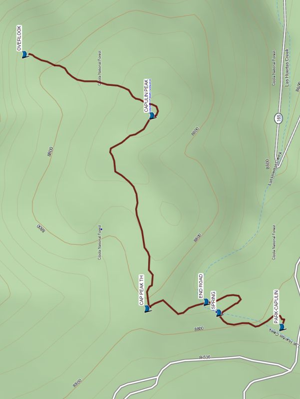
Map File Source: Garmin BaseCamp
 Hike Key: H10710
Last Updated: 09/13/2023 12:48pm
Last Updated By: Dawn McIntyre
Hike Class: B (Moderate)
Hike Distance: 2.1 mi
Minimum Elevation: 8750 ft
Elevation Change: 170 ft
Total Uphill: 440 ft
Total Downhill: 440 ft
Avg. Grade: 6 %
Route Type: InOut
Protected: No
On Trail: Yes
Paved or Gravel Roads: Yes
GPS Advised: Yes
Drive Distance Round Trip: 60 mi
Drive Time One-Way: 0:45
Hiking Seasons: Spring, Summer, and Fall
New Mexico Game Unit:
Hike Status: Published
Attractions: Fall Color, Forest, Views, and Wildflowers
Highlights
A trail to a small spring, then to a wonderful 360 degree overlook.
CautionsNone.
Trailhead Directions
From Cedar Crest, take the road that goes to Sandia Peak. Pass the Balsam Glade picnic area on your right and go about 1.4 mi further to the Capulin parking lot.
Actual Hike
From parking, go to the SPRING (0.2 mi). Follow the road to END ROAD (0.3 mi) and continue generally north to the CAP PEAK TH (0.4 mi). Turn right (east) and continue in the forest to CAPULIN PEAK (0.8 mi). Then go northeast relatively steeply downhill (11% grade) to the OVERLOOK (1.0 mi) where the trail ends. Enjoy the views all around you. Return the way you came.
Waypoints
PARK-CAPULIN: N35 12.956, W106 24.929
SPRING: N35 13.047, W106 24.903
END ROAD: N35 13.065, W106 24.883
CAP PEAK TH: N35 13.151, W106 24.895
CAPULIN PEAK: N35 13.144, W106 24.547
OVERLOOK: N35 13.328, W106 24.436
Hike GPS File Name: CapSpr-CapPk-Overlook_WayTrack_MW.gpx
Hike GPS File: Click link to download hike waytrack file
Text Author: Marilyn Warrant
Map Author: Marilyn Warrant
Waypoints Author: Marilyn Warrant
Track Author: Marilyn Warrant
Maintainer: Marilyn Warrant
Editor: Dawn McIntyre