Belen Bosque South Hike
In Los Lunas Region
Map File Source: NG Topo
 Hike Key: H10476
Last Updated: 12/05/2023 8:25pm
Last Updated By: Marilyn Fixer
Hike Class: A (Easy)
Hike Distance: 3.9 mi
Minimum Elevation: 4793 ft
Elevation Change: 10 ft
Total Uphill: 10 ft
Total Downhill: 10 ft
Avg. Grade: %
Route Type: InOut
On Trail: Yes
Paved or Gravel Roads: Yes
GPS Advised: No
Drive Distance Round Trip: 84 mi
Drive Time One-Way: 1:00
Hiking Seasons: Spring, Fall, and Winter
New Mexico Game Unit: 14
Hike Status: Published
Highlights
This hike along the Bosque represents what might have been in Albuquerque 50 years ago before restoration started.
CautionsNone.
Trailhead Directions
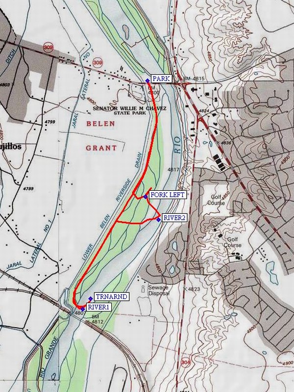
South on I-25 to exit 195 (Belen North). Follow Business I-25 going east that curves around to the south. At 4.5 mi make a left turn (East) onto state 309 (Reinken Ave). Cross the railroad tracks. At 2.2 miles east on Reinken, turn left (North) at East side of west drain just before the river. Go downhill to circle parking area centered on power pole and park. (The Middle Rio Grande Conservancy District recommends that we park in the area just East of the driveway on the North side of the road and cross over the highway instead of parking on the South side of the road to avoid being blocked in by fishermen.)
Actual Hike
Cross the 4-lane road. Proceed down the East side of levee along the river drain. At about 1.5 mi we approach the BNSF railroad tracks. The drain and hike track angles SE to the River (RIVER1 (1.6 mi)) and turnaround (TRNARND (1.7 mi)). Return North past double jetty jacks (see Taking out the jacks: issues of jetty jack removal in bosque and river restoration planning) and turn on road to East into Bosque. This area has experienced a fire and is being cleared and replanted. Follow the main road around to the north. A side trip to the River (RIVER2 (2.7 mi)) is possible going through the cleared brush, though footing on down brush is not easy. Turn back toward the levee at FORK LEFT (2.9 mi), then back North to the van.
Comments
This Bosque represents what might have been in Albuquerque 50 years ago before restoration started. There are fields, livestock, etc. across the drain to the west. The River is somewhat different at Belen; there is much less city noise and interesting rail traffic at the South end of the hike. There is significant new planting in area of burn, but just starting.
All the land from the drain to the river is the responsibility of the Middle Rio Grande Conservancy District. We have their permission to hike this area. Stay on the East side of the drain!!
A phone call to the Belen Schools Maintenance Dept. at 966-1700 can request access to the restrooms at what was the Willie Chavez park. They will need to know the hours the hikers will be in the area to provide restroom access. The Harvey House Museum can also be added to this hike. It opens at 12:30 PM.
PARK: N34 39.184, W106 44.439
RIVER1: N34 37.902, W106 44.878
TRNARND: N34 37.962, W106 44.825
RIVER2: N34 38.403, W106 44.362
FORK LEFT: N34 38.533, W106 44.451
Hike GPS File Name: BelenBosqueSouthWayTrack_WH.gpx
Hike GPS File: Click link to download hike waytrack file
Text Author: Theodore (Ted) Cooley
Map Author: Marilyn Warrant
Waypoints Author: Bill Hansen
Track Author: Bill Hansen
Maintainer: Not Assigned
Editor: Randy Simons