Albuquerque Trail – 4th Of July Loop Hike
In Manzano Mountains East Region
Map File Source: DeLorme
 Hike Key: H10437
Last Updated: 03/04/2021 12:00am
Last Updated By: Marilyn Fixer
Hike Class: C (Challenging)
Hike Distance: 5.3 mi
Minimum Elevation: 7425 ft
Elevation Change: 835 ft
Total Uphill: 980 ft
Total Downhill: 980 ft
Avg. Grade: 9 %
Route Type: CCW Loop
On Trail: Yes
Paved or Gravel Roads: No
GPS Advised: Yes
Drive Distance Round Trip: 140 mi
Drive Time One-Way: 1:30
Hiking Seasons: Spring, Summer, and Fall
New Mexico Game Unit: 14
Hike Status: Published
Highlights
A good fall foliage hike for maples.
CautionsHiking poles recommended for the downhill return.
Trailhead Directions
I-40 East to Tijeras exit, south on SR 337 to its end, right (west) on SR 55 to Tajique. Look for sign in Tajique for “4th of July Canyon.” Take FR 55 about 6.5 miles. At the 6.5 mile point the road will bend to the left. Just beyond the bend on the right side of the road there will be two large parking areas. Park here.
Actual Hike
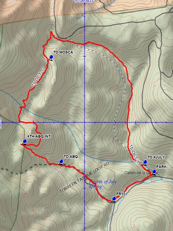
From PARK (0.0 mi) take Albuquerque trail north. The trail will gain elevation and loop around to the west, then south. When 4TH-ABQ INT (3.5 mi) is reached turn left downhill on the Fourth of July trail. This trail will pass through the campground and reach FR55 (4.8 mi). Turn left and go down FR 55 to parking.
Comments
A good fall foliage hike for maples. When it is not foliage season you may want to take the trail to the left at [TO ABQ] rather than go through the campground.
WaypointsPARK: N34 47.604, W106 22.352
TO 4JULY: N34 47.676, W106 22.440
TO MOSCA: N34 48.472, W106 23.359
4TH-ABQ INT: N34 47.834, W106 23.619
TO ABQ: N34 47.681, W106 23.262
FR55: N34 47.399, W106 22.745
Hike GPS File Name: AlbuquerqueTrail-4thOfJulyLoopWayTrack_DBDB.gpx
Hike GPS File: Click link to download hike waytrack file
Text Author: Dick Brown
Map Author: Dick Brown
Waypoints Author: Dick Brown
Track Author: Dick Brown
Maintainer: Marilyn Warrant
Editor: Marilyn Warrant