10K North Hike
In Sandia Mountain East Region
Map File Source: DeLorme
 Hike Key: H10104
Last Updated: 03/20/2023 2:08pm
Last Updated By: Marilyn Fixer
Hike Class: C (Challenging)
Hike Distance: 5.2 mi
Minimum Elevation: 9650 ft
Elevation Change: 380 ft
Total Uphill: 1135 ft
Total Downhill: 1135 ft
Avg. Grade: 10 %
Route Type: InOut
On Trail: Yes
Paved or Gravel Roads: Yes
GPS Advised: No
Hiker Limit (NF/BLM/NP): 15 (Sandia Wilderness)
Drive Distance Round Trip: 60 mi
Drive Time One-Way: 1:00
Hiking Seasons: Spring, Summer, and Fall
New Mexico Game Unit: 8
Hike Status: Published
Attractions: Forest
Highlights
Forest hike with views to the west. Beautiful fall color from the aspens.
CautionsLots of steady but gradual uphill on the return from lunch.
Trailhead Directions
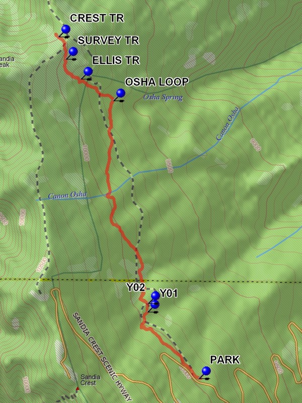
From Albuquerque take 1-40 east to Tijeras exit 175, then go north on SR 14 to SR 536. Go east up the mountain for 10.1 miles to the parking on the right at the 10K trailhead. A three dollar fee or Golden Age Pass is required to PARK (0.0 mi) here.
Actual Hike
The trail starts at the far end of the 10K parking area. The trail goes northward from that point, and is generally shaded by trees. At Y01 (0.6 mi) go left. A short distance beyond this point at Y02 (0.6 mi) go left again. The trail generally follows the contour line, going up and down but losing elevation. At the OSHA LOOP (2.0 mi) Trail terminus, stay left up hill. The trail crosses the ELLIS TR (2.3 mi). This broad swath was originally intended to be a road. The trail crosses the SURVEY TR (2.5 mi) and continues to the top of the mountain where it crosses the CREST TR (2.7 mi). From this point it is a short distance to the Del Agua overlook. Enjoy the view. Return to parking the way you came
Comments
Trail is so named because it generally follows the 10,000 foot contour line. At the far end of the hike there is a view to the west overlooking Del Agua Canyon. Cool in the summer. During the fall foliage season a large stand of yellow aspens covers the northwest facing slope.
WaypointsPARK: N 35 12.585, W 106 26.139
Y01: N 35 12.911, W 106 26.448
Y02: N 35 12.954, W 106 26.446
OSHA LOOP: N 35 13.952, W 106 26.654
ELLIS TR: N 35 14.057, W 106 26.852
SURVEY TR: N 35 14.156, W 106 26.942
CREST TR: N 35 14.265, W 106 26.986
Hike GPS File Name: 10KNorthWayTrack_DBDB
Hike GPS File: Click link to download hike waytrack file
Text Author: Dick Brown
Map Author: Dick Brown
Waypoints Author: Dick Brown
Track Author: Dick Brown
Maintainer: Ken Smith
Editor: Marilyn Warrant