Schoolhouse Canyon Hike
In Jemez Mountains Region
Map File Source: DeLorme
 Hike Key: H10187
Last Updated: 09/05/2023 3:19pm
Last Updated By: Marilyn Warrant
Hike Class: C (Challenging)
Hike Distance: 4 mi
Minimum Elevation: 7260 ft
Elevation Change: 915 ft
Total Uphill: 990 ft
Total Downhill: 990 ft
Avg. Grade: 11 %
Route Type: Lollypop
On Trail: No
Paved or Gravel Roads: Yes
GPS Advised: No
Drive Distance Round Trip: 120 mi
Drive Time One-Way: 1:15
Hiking Seasons: Spring, Summer, and Fall
New Mexico Game Unit: 6A
Hike Status: Published
Highlights
Interesting rock formations.
CautionsSteep rocky road so hiking poles are recommended. Can be hot, so bring extra water.
Trailhead Directions
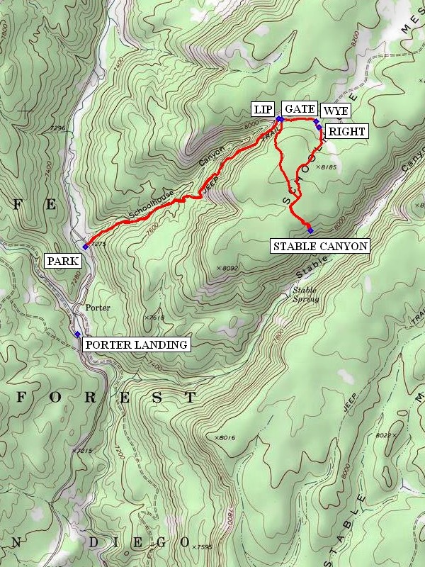
From Albuquerque take I-25 north to Bernalillo Exit 242 Go west on US 550 to San Ysidro. Go north on SR 4 to SR 485. Take SR 485 and drive through the Gilman Tunnels and on to PORTER LANDING where a right turn takes you across the bridge which goes across the Rio Guadalupe. About 0.4 miles beyond the bridge and after a cattle guard PARK (0.0 mi) on the left in the shaded parking area.
Actual Hike
The trail starts across the road at the right end of the split rail fence. The hike up Schoolhouse Canyon will be on an old abandoned two track clinging to the south side of the canyon. At the LIP (1.3 mi) of the canyon there will be a good view down the canyon and some shade where you can sit and rest. After a short distance pass through a fence GATE (1.3 mi). Follow the road, and at the WYE (1.5 mi) keep to the right. After a short distance again stay RIGHT (1.5 mi). Stay on the road which will curve around to the south and traverse Schoolhouse Mesa through a pine forest.
Waypoints
PORTER LANDING: N35 49.079, W106 47.268
PARK: N35 49.438, W106 47.230
LIP: N35 49.969, W106 46.246
GATE: N35 49.966, W106 46.231
WYE: N35 49.957, W106 46.055
RIGHT: N35 49.934, W106 46.042
STABLE CANYON: N35 49.508, W106 46.086
Jemez Falls Bathrooms: N35 46.313, W106 41.444
Hike GPS File Name: SchoolhouseCanyonWayTrack_DBDB.gpx
Hike GPS File: Click link to download hike waytrack file
Text Author: Dick Brown
Map Author: Marilyn Warrant
Waypoints Author: Dick Brown
Track Author: Dick Brown
Maintainer: Not Assigned
Editor: Marilyn Warrant