Peralta – Paliza Hike
In Jemez Mountains Region
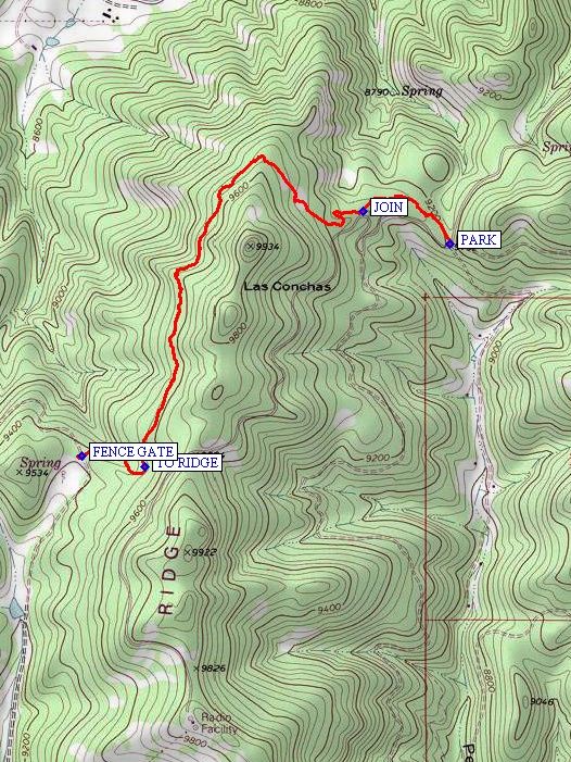
Map File Source: NG Topo
 Hike Key: H10174
Last Updated: 11/23/2021 12:00am
Last Updated By: Marilyn Fixer
Hike Class: C (Challenging)
Hike Distance: 4.8 mi
Minimum Elevation: 9192 ft
Elevation Change: 417 ft
Total Uphill: 730 ft
Total Downhill: 730 ft
Avg. Grade: 9 %
Route Type: InOut
On Trail:
Paved or Gravel Roads:
GPS Advised:
Drive Distance Round Trip: 160 mi
Drive Time One-Way: 2:00
Hiking Seasons:
New Mexico Game Unit: 6A
Hike Status: Inactive
Cautions
In the 2011 Las Conchas burn scar.
Trailhead Directions
I-25 N to exit 242, W on US 550 to San Ysidro, right (north) on SR 4 to La Cueva. Take SR 4 for 12.4 mi. east of La Cueva one mile past Las Conchas Trailhead, past Corral Canyon Trailhead to one quarter mile past milepost 38. Turn off to the right onto FR 280. Drive for a little over two miles (about 10 min.) to a “K” intersection of roads and park there. The main road swoops to the right and there is a Forest Service iron gate straight ahead.
Actual Hike
This hike goes from the top of Peralta Canyon over to the top of Paliza Canyon. Lush with tall green grass and great views to the north toward Valles Grande and Redondo Peak. The trail starts off to the right and follows along the road for a while then goes on the other side of the ridge. An option is to come back on the road after lunching at Paliza Canyon.
Comments
The road makes a loop off SR 4 between mileposts 14 and 15. Avoid going on this hike during the monsoon.
Later in San Ysidro we stopped and toured the Feed Store with its collection of exotic mounted animals (some even from Africa). Also, south of Jemez Springs we visited an unusual house by architect, Bart Prince on San Diego Dr. (turn in at Dancing Bear Gallery).
WaypointsFR 280: N 35 49.660, W 106 29.835
PARK: N 35 48.114, W 106 30.762
JOIN: N 35 48.203, W 106 31.050
TO RIDGE: N 35 47.514, W 106 31.773
FENCE GATE: N 35 47.541, W 106 31.983
Hike GPS File Name: Peralta-PalizaWayTrack_DBDB.gpx
Hike GPS File: Click link to download hike waytrack file
Text Author: Roger Holloway
Map Author: Marilyn Warrant
Waypoints Author: Dick Brown
Track Author: Dick Brown
Maintainer: Not Assigned
Editor: Marilyn Warrant