Old – New Embudo Trails Hike
In Sandia Mountain West Region
Map File Source: Garmin BaseCamp
 Hike Key: H10703
Last Updated: 12/05/2023 9:40pm
Last Updated By: Marilyn Fixer
Hike Class: E (Most difficult)
Hike Distance: 7.6 mi
Minimum Elevation: 6190 ft
Elevation Change: 1940 ft
Total Uphill: 2310 ft
Total Downhill: 2310 ft
Avg. Grade: 9 %
Route Type: Lollypop
On Trail: No
Paved or Gravel Roads: Yes
GPS Advised: Yes
Hiker Limit (NF/BLM/NP): 15 (Sandia Wilderness)
Drive Distance Round Trip: 22 mi
Drive Time One-Way: 0:45
Hiking Seasons: Spring, Summer, and Fall
New Mexico Game Unit: 8
Hike Status: In Process
Highlights
This hike takes you through a narrow, rock-lined canyon that eventually opens up with mountain ridges in all directions — South Peak to the east, Post Peak and Post Pass to the south, Whitewash trail ridge to the north, and various foothills in between.
CautionsThe lower canyon involves rocky areas that can be slippery. The Old Embudo trail definitely requires good cleats (not YakTrax) when it’s icy and snow covered. Trekking poles are recommended.
Trailhead DirectionsIn Albuquerque take Tramway to Indian School and go east to the gate and PARK on the right in the small parking area before the gate.
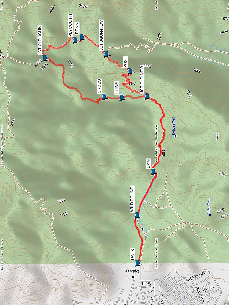
Actual HikeFrom PARK, head up the (new) Embudo trail past the Wilderness boundary (WILD BOUND, 0.5 mi) and the DAM (1.0 mi) to the JCT OLD-NEW Embudo trails (1.9 mi) where you start the loop part of the lollypop. Turn onto the Old trail that goes north in between the new trail to the east and Embudo stream to the west. As an optional side trip, the rock ruins of a shepherd’s cabin can be reached by going north up a drainage at RUINS (2.2 mi). The actual cabin is about 300 yards up a gradually sloping ridge at CABIN (not shown on the map). This path is off trail but not brushy if you can pick your way in between the shrubs and cactus. Continuing on the Old Embudo trail, cross the Embudo stream at CROSS (2.4 mi). The path leaves the stream steeply on the west side and directly next to a 10-foot boulder. There is also a 5-foot boulder on the stream’s east side at this point. This crossing is easy to miss so don’t venture far until you’re back on an obvious path.
The old trail now climbs to the north and away from the Embudo stream which turns to the ENE. The trail continues to climb and begins the first of three steep sections with this first being longest. The ridge top is finally gained after climbing 400′ and it turns to the NE. This section is fairly level with great views of Embudo canyon to the south and South Peak directly ahead to the NE. In about a quarter mile, the second steep section begins but it is much shorter. Snow can linger in this area. After leveling off again for a short distance the final steep section begins that can also accumulate some snow. Three Gun Spring trail is shortly encountered at JCT OLD-3GUN (3.4 mi). Turn east which is downhill. Keep on the lookout for the Plymouth Rock medallion tree at PLYMOUTH (4.0 mi) which is about 50 feet off the trail on the east side. You can see the shiny medallion from the trail. A second medallion tree is right on the trail at PENN (4.1 mi) which commemorates Pennsylvania’s statehood. Turn west at JCT 3GUN-NEW (4.5 mi) which is the upper terminus of the new Embudo trail. The new Embudo trail drops fairly rapidly from this point for about 1/3 mile where it reaches the beginning of POST (4.9 mi) pass. The actual pass is about 1/3 mile further south along the ridge with Post peak directly south of that. Turn west at POST and begin a series of three switchbacks that will drop you back near the canyon bottom. It’s only a short distance before JCT OLD-NEW (5.6 mi) is reached where you initially left the new Embudo trail. Retrace your path from this point back to the Embudo trailhead parking lot.
CommentsSheep once grazed in this canyon but only a few fences and rock ruins remain. Taking the Old Embudo trail from Indian School TH to Oso Pass is 0.7 miles shorter than the current Embudo trail.
WaypointsPARK: N35 05.939, W106 28.802
WILD BOUND: N35 05.942, W106 28.287
DAM: N35 05.802, W106 27.817
JCT OLD-NEW: N35 05.859, W106 27.005
RUINS: N35 06.075, W106 27.020
CABIN: N35 06.206, W106 26.970
CROSS: N35 06.226, W106 27.010
JCT OLD-3GUN: N35 06.738, W106 26.593
JCT 3GUN-NEW: N35 06.210, W106 26.549
PLYMOUTH: N35 06.477 W106 26.400
PENN: N35 06.420, W106 26.370
POST: N35 06.000, W106 26.732
JCT OLD-NEW: N35 05.859, W106 27.005
Hike GPS File Name: Old-NewEmbudoTrls_CW_JH.gpx
Hike GPS File: Click link to download hike waytrack file
Text Author: Bill Davidson
Map Author: Marilyn Warrant
Waypoints Author:
Track Author:
Maintainer: Randy Simons
Editor: Dawn McIntyre