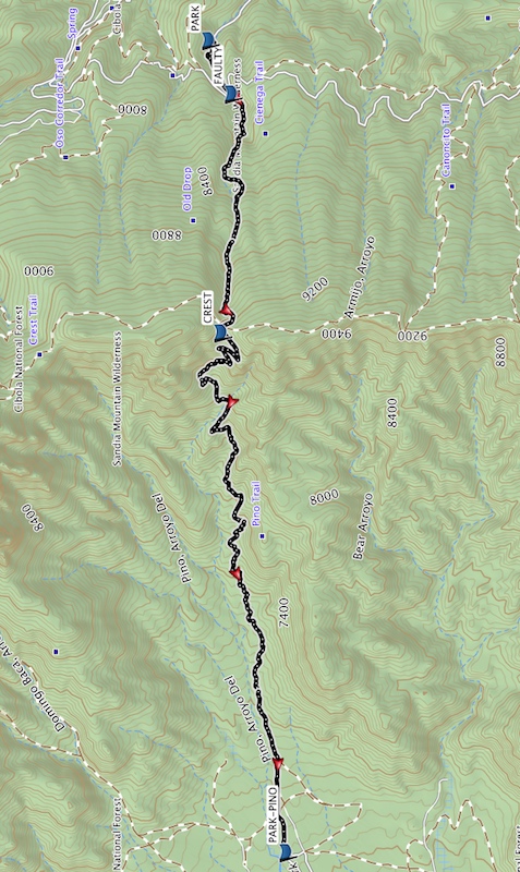
Cienega Trail – Crest – Pino Trail Hike
In Sandia Mountain East Region
Map File Source: Garmin BaseCamp
 Hike Key: H10647
Last Updated: 12/05/2023 8:54pm
Last Updated By: Marilyn Fixer
Hike Class: E (Most difficult)
Hike Distance: 6.4 mi
Minimum Elevation: 6470 ft
Elevation Change: 2730 ft
Total Uphill: 1660 ft
Total Downhill: 2760 ft
Avg. Grade: 14 %
Route Type: Crossover
On Trail: Yes
Paved or Gravel Roads: Yes
GPS Advised: Yes
Hiker Limit (NF/BLM/NP): 15 (Sandia Wilderness)
Drive Distance Round Trip: 30 mi
Drive Time One-Way: 0:30
Hiking Seasons: Spring, Summer, and Fall
New Mexico Game Unit: 8
Hike Status: Published
Highlights
A strenuous hike up to the Crest from the east side of the Sandia Mts. then back down on one of two major trails leading to the Crest from the west side. Lots of tree cover at higher elevations and vistas of ABQ below.
CautionsThis is a steep one, so bring your hiking poles, bring plenty of water, and wear your most comfortable hiking boots.
Trailhead DirectionsTo leave from the Cienega TH: From Albuquerque take I-40 east to Tijeras exit 175. North on SR 14. Left on Sandia Crest Scenic Byway (SR 536). Watch for signs. Cienega Canyon and Sulfur Canyon will be on your left, just after milepost 1. Almost immediately there is a fork to the left (south to Cienega Trailhead). Take that road over the hill to the T intersection and go right. The parking area and trailhead are at the end of the road.
To leave from the Pino TH: North on Tramway past Academy, look for signs leading right to Elena Gallegos Picnic Grounds and park there.
Actual HikeThis is a strenuous hike conducted simultaneously by two groups – one hiking up to the Crest on the east side of the Sandias via the Cienega Trail, and one hiking up to the Crest on the west side, via the Pino trail. The two groups meet at the top, exchange van keys and descend via the trail they didn’t take up (i.e. the group that hiked up Pino hikes down Cienega). They return to the Senior Center via the van waiting for them at the end of their descent.
CommentsThis hike requires two vans and drivers. If there has been recent snow, the trails could be icy and hikers should carry Yaktrax or other boot traction devices.
The hiker limit applies to each of the two one-way hikes.
WaypointsAccess
CIENEGA CNYN: N35 09.963, W106 21.719
Hike
PARK: N35 10.193, W106 23.045
FAULTY: N35 10.077, W106 23.384
CREST: N35 10.130, W106 24.896
PARK-PINO: N35 09.799, W106 28.190
Hike GPS File Name: Cienega-Crest-Pino_DMDM.gpx
Hike GPS File: Click link to download hike waytrack file
Text Author: Nan Burke
Map Author: Dawn McIntyre
Waypoints Author: Marilyn Warrant
Track Author: Dawn McIntyre
Maintainer: Dawn McIntyre
Editor: Randy Simons